- Catalogs
- Hi-Target Surveying Instrument Co.,Ltd
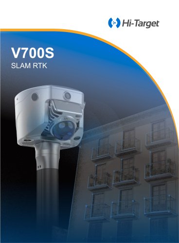
- Hi-Target/GNSS Receiver/V500
- Company
- Products
- Catalogs
- News & Trends
- Exhibitions
Hi-Target/GNSS Receiver/V500
1 /2Pages

Hi-Target/GNSS Receiver/V500
1 /2Pages
Catalog excerpts

TECHNICAL SPECIFICATIONS GNSS Feature Specification Channels Static and Fast Static Post Processing Kinematic (PPK / Stop & Go) PPP Code Differential GNSS Positioning Real Time Kinematic (RTK) Time to first Fix Hi-Fix[5] Tilt Survey Performance[3] AR stakeout accuracy Dimensions (W x H) Weight Operation temperature Storage temperature Humidity Water/dustproof Shock and vibration Free fall Internal Battery[4] External power H: 8mm + 1ppm RMS | V: 15mm + 1ppm RMS Initialization time: Typically 10 min for base and 5 min for rover Initialization reliability: Typically>99.9% H: 10cm Initialization time: Typically <10s | Initialization reliability: Typically > 99.9% Cold start:< 45s | Additional horizontal pole-tilt uncertainty typically less than 8mm+0.7mm/°tilt (2.5cm accuracy in the inclination of 60°) 1cm 130mm × 68mm ≤ 0.75kg ( 1.65lb ) -40℃~+75℃(-40℉~+167℉) -55℃~+85℃(-67℉~+185℉) 100% non-condensing IP68 dustproof, protected from temporary immersion to depth of 1.0m (3.28ft) MIL-STD-810G, 514.6 Designed to survive a 2m(6.56ft) natural fall onto concrete Internal 7.4V / 6800mAh lithium-ion rechargeable battery RTK rover(UHF/Cellular): up to 24 hours Using standard smartphone chargers or external power banks (Support 5V 2.8A Type-C USB external charging) 1 × USB type C port; 1 × SMA antenna port Frequency 2.4GHz, Supports 802.11 a/b/g/n Control Panel Physical button LED Lights Storage Output format Output rate Static data format Real Time Kinematic (RTK) High-Precision Static Network Mode Protocol: HI-TARGET, TRIMTALK450S, TRIMMARK III, SATEL-3AS, TRANSEOT, etc. Working Range: Typically 3~5km, optimal 8~15km Channel: 116(16 scalable) Professional starlight night vision HD camera, large viewing angle, support live view stakeout 1 Satellite, Signal, Power 16GB ROM internal storage ASCII: NMEA-0183 1Hz~20Hz GNS, Rinex RTCM2.X, RTCM3.X VRS, FKP, MAC, Support NTRIP protocol Note: [1]BDS B2b, GALILEO E6, QZSS L6, IRNSS L5 can be provided by firmware upgrade. [2]The measurement accuracy, precision, reliability and initialization time depend on various factors, including tilt angle, number of satellites, geometric distribution, observation time, atmospheric conditions and multi-path validation, etc. The data are derived under normal conditions. [3]Irregular operations such as rapid rotation and high-intensity vibration may affect the inertial navigation accuracy. [4]The battery operating time is related to the operating environment, operating temperature and battery life [5]Accuracies are dependent on GNSS satellite availability. Hi-Fix Positioning ends after 5 minutes without differential data.Hi-Fix is not available in all regions, check with your local sales representative for more information. Descriptions and Specifications are subject to change without notice AUTHORIZED DISTRIBUTION PARTNER Addess: Building 13, Tian'An Technology Zone, No. 555, Panyu North Rd., Panyu District, Guangzhou, China (511400) TEL: +86-20-2288 3944 E-mail: [email protected] www.hi-
Open the catalog to page 1
Professional Field Controller Compact GNSS RTK with Long Endurance for Accurate Stakeout Equipped with an upgraded high-definition starlight camera, V500 brings out an excellent visual stakeout experience in low-light conditions. The The iHand55 Handheld Controller is a professional field controller with a big vision. More features of the latest Hi-Survey Software contribute to achieving high intelligence. Keeping robust and reliable in fieldwork under any conditions, iHand55 is a perfect choice for your survey work. compact and lightweight design makes V500 a feasible and portable choice for...
Open the catalog to page 2All Hi-Target Surveying Instrument Co.,Ltd catalogs and technical brochures
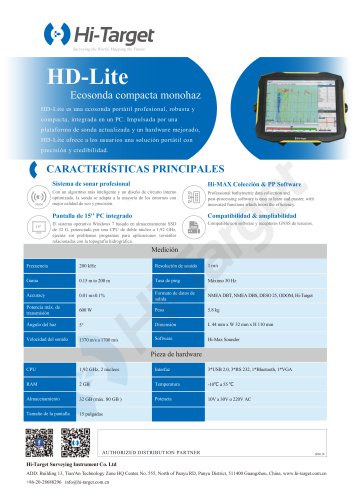 HD-Lite
1 Page
 Hi-Target/USV/ iBoat BS12
2 Pages
 Hi-Target catalog-20230907s
20 Pages
 Hi-Target/GNSS Receiver/vRTK
4 Pages
 Hi-Target/GNSS Receiver/V200
2 Pages
 Hi-Target/USV/ iBoat BS3
2 Pages
 Hi-Target/Auto Level/ HT-32
2 Pages


Archived catalogs

- Management software solution
- Analysis software solution
- Process software
- Windows software
- Real-time software
- Touch screen tablet
- Wireless tablet
- Rugged tablet
- 3D software solution
- Industrial software
- Interface software
- Bluetooth tablet
- WiFi tablet
- GNSS tablet
- Industrial tablet
- Android tablet
- Waterproof tablet
- Real-time monitoring module
- Tablet with NFC reader
- Measurement monitoring module