X-PAD Ultimate
1 /5Pages

X-PAD Ultimate
1 /5Pages
Catalog excerpts

X-PAD ULTIMATE X-PAD Ultimate is a tailored, flexible, modular, ideal, customised software for high end topographic tasks, such as measure, stake-out, cadastral, BIM check and control, roading, mapping, bathymetry and GIS. Running on Android™, it brings the best technologies to topography. X-PAD Ultimate ensures productivity in the field and provides perfect integration between measuring instruments. Available in two versions, one dedicated to the professional surveyors and one dedicated to construction companies, X-PAD Ultimate offers to both a specific working environment and a set of dedicated features. raoaDD geomax-positioning.com ©2019 Hexagon AB and/or its subsidiaries and affiliates. All rights reserved. Visit our website to find your local distributor: geomax-positioning.com
Open the catalog to page 1
“The ultimate solution for all those who want the best in the field without compromise.” Increase productivity X-PAD Ultimate is the most advanced field software solution for all users that are looking for a tool that grants productivity, easiness of use, scalability and full control of the data. Running on Android devices, X-PAD Ultimate brings the best technology directly to the field and on your hand: a full 3D viewer and CAD system to view and edit the drawings, integration of your data with all map types and support of the camera for augmented reality. Direct data exchange with a cloud platform...
Open the catalog to page 2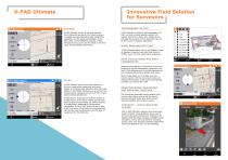
Innovative Field Solution for Surveyors Reference line Survey X-PAD Ultimate Survey is the best solution for professional surveyors that need accuracy, complete features, flexibility, data integration, scalability and the latest technologies in the field. With a set of different modules, X-PAD Ultimate Survey covers all the needs in the field using TPS and GNSS instruments. TOPOGRAPHIC 3D CAD X-PAD Ultimate includes a real topographic 3D CAD, not just a simple graphic viewer, with specific functions to draw, edit, measure and calculate the position of new elements that can be then used in stakeout...
Open the catalog to page 3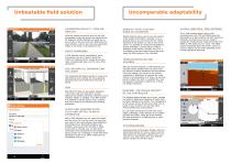
Uncomparable adaptability i-:-1Unbeatable field solution AUGMENTED REALITY. TURN ON REALITY! Point the camera to the site and you can see immediately where the points and elements are for stakeout. X-PAD Ultimate will guide you in the vicinity of the point and then determine the exact location, but you can also use augmented reality to see what is not possible to see. VOICE COMMANDS X-PAD Ultimate can be controlled by voice commands; you don't need to touch the screen to measure points, change the survey code, change target type, and for many other operations. GIS: RECORD ALL INFORMATION YOU...
Open the catalog to page 4
X-PAD Ultimate modules X-PAD Ultimate is specifically tailored for users and has the right modules and language for surveyors and construction experts, as it is split in two modules: Survey and Build. 0919 - 876854 en Copyright GeoMax AG. Illustrations, descriptions and technical specifications are not binding and may change. All trademarks and trade names are those of their respective owners. GEOMAX AUTHORISED DISTRIBUTION PARTNER BE MAXLearn more at: geomax-positioning.com
Open the catalog to page 5All GeoMax catalogs and technical brochures
 GeoMax General Catalogue
37 Pages
 Zenith60 Datasheet
2 Pages
 Zeta125 Series
2 Pages
 Zenith GNSS family
8 Pages
 TPS Family Brochure
7 Pages
 Zoom 75
2 Pages
 Zoom 95
2 Pages
 X-Pad 365 Broschure
3 Pages
 X-Pad CalMaster Flyer
2 Pages
 Zenius800 Broschure
3 Pages
 Zenius5 & ZeniusX
2 Pages
 Zenith16
2 Pages
 ZAL300 Series
2 Pages
 Locators Brochure
8 Pages
 ZAL200 Series
2 Pages
 ZAL100 Series
2 Pages
 Zoom3D
6 Pages
 Zoom25
2 Pages
 Zoom40
2 Pages
 Zoom50
2 Pages
 Laser Rotators Brochure
8 Pages
 X-PAD Office Fusion
6 Pages


Archived catalogs
 Zenith35 Pro Series
4 Pages
 ZDL700 Broschure
4 Pages
 Zoom90 Series
4 Pages
 GeoMax Zoom70 Brochure
4 Pages
 Zoom90
4 Pages
- Management software solution
- Data logger
- Analysis software solution
- Computer-aided design software
- Cloud-based software
- Touch screen tablet
- Wireless tablet
- Design software solution
- Rugged tablet
- 3D software solution
- Interface software
- Measurement software
- Bluetooth tablet
- WiFi tablet
- Quality software
- Visualization software solution
- GNSS tablet
- Android tablet
- EDM software
- Waterproof tablet