- Catalogs
- ComNav Technology Ltd.
- Venus Laser RTK
- Company
- Products
- Catalogs
- News & Trends
- Exhibitions
Venus Laser RTK
1 /2Pages

Venus Laser RTK
1 /2Pages
Catalog excerpts

Software Survey Master Optional Compatible with most of Android devices Microsurvey FieldGenius Android Easier survey workflow via Wizard function Microsurvey FieldGenius Windows Support up to 60° IMU tilt compensation Bluetooth: 5.0 Dual-Mode Bluetooth NFC: NFC Fast Connection Interface: USB TYPE-C Support Surface Stake, Mapping Survey and etc. to serve various survey tasks Performance Specification Support CAD import and directly use for stake out operations Signal Re-acquisition: ≤1s Cold Start: ≤45s Hot start: ≤15 s RTK Initialization Time: <10s(Baseline≤10km) Initialization reliability: ≥99% Data Update Rate: 1Hz, 2Hz, 5Hz, 10Hz, 20Hz Environmental Specification Working Temperature: -20℃~+60℃ Storage Temperature: -30℃~+70℃ Humidity: 100% non-condensing Water- & Dustproof: IP67 Shock: Survive a 2m drop onto the concrete Vibration: MIL-STD-810G Method 514.6 procedureⅠ Physical Specification Static and Fast Static Laser Tilt Measurement ≤5.5cm (2m range, ≤60°Tilt in handheld mode) Data Format Post-processing Software SinoGNSS Compass solution software Correction data I/O: RTCM2.X, 3.X,CMR(GPSonly),CMR+(GPSonly) Position data output: - ASCII: NMEA-0183 GSV, RMC, HDT, GGA, GSA, ZDA, VTG, GST; PTNL, PJK; PTNL, AVR; PTNL, GGK -ComNav Binary update to 20 Hz Support GNSS observation data in RINEX and ComNav Raw Binary Data format Voltage: 5/9V Power Consumption: 1.45W Over Current Protection Voltage: 30V, VBUS 9.99V Charging Time: <4h(QC2.0) Working time: ≥20h Output analysis reports in various formats (web format, DXF, TXT, KML) Housing Material: Plastic Dimension: 80±1mm(L), 70±1mm(W), 150±1mm(H) Weight: 380g Range Pole Interface: M8 thread Laser Specification Range: 10m Accuracy(room temperature): (3-5)mm + 1ppm Measuring Frequency: Classic Value: 3Hz Maximum Value: 5Hz Laser Injection Power: 0.9mW~1.5mW Working Temperature: -20℃~+50℃ Storage Temperature: -30℃~+60℃ Specifications subject to change without notice. Venus Laser RTK Universe Series GNSS Receiver Provide the complete GPS/GLONASS/BeiDou/GALILEO post-processing solution Support different post-processing in static and kinematic modes Signal Tracking Support all survey modes, including Static, PPK and RTK Support Convert function from ComNavBinary raw file to RINEX GNSS Surveying System Supports DJI’s P4R data format. Processing results can be imported into photogrammetry LASER RTK - INNOVATION MAKES THE DIFFERENCE and 3D modeling software directly Building 2, No. 618 Chengliu Middle Road, 201801, Shanghai, China Web: www.comnavtech.com Email: [email protected] Fax: +86 21 54309582 2024, ComNav Technology Ltd. All rights reserved. is the official trade mark of ComNav Technology Ltd., registered in People’s Republic of China, EU, USA and Canada. All other trademarks are the property
Open the catalog to page 1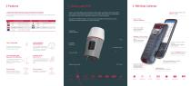
LASER DISTANCE METER ENABLES RODLESS SURVEY Innovatively equipped with a laser distance meter, Venus makes rod-free stakeout and measurement possible, greatly expanding the working scope. SATELLITE TRACKING 5.5 inch sunlight readable screen 1080P HD display Venus is an innovative GNSS receiver combined with laser and IMU. Laser distance meter makes rodless survey possible, enabling GNSS surveying beyond usual constraints. IMU achieves 60° tilt compensation in both traditional and laser modes, supports free calibration and 10-second initialization. Integrated the SinoGNSS K8 platform, Venus features...
Open the catalog to page 2All ComNav Technology Ltd. catalogs and technical brochures
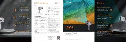 LS600 Laser Scanner
2 Pages
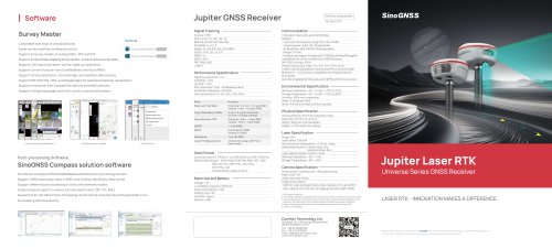 SinoGNSS Jupiter Laser RTK
2 Pages
 AT600 Chock Ring Antenna
1 Page
 M300 Pro 2023 GNSS Receiver
2 Pages
 K823 GNSS Module
2 Pages
 AT410 GNSS Antenna
2 Pages
 M900 GNSS Receiver
2 Pages
 U70 Datalink Module
1 Page
 N3 IMU GNSS Receiver
2 Pages
 AT360 Geodetic Antenna
1 Page
 P8 Tablet
2 Pages
 R60 Data Collector
2 Pages
 N2 GNSS Palm Receiver
2 Pages
 Mars Pro Laser RTK
2 Pages
 Mars Laser RTK
2 Pages
 Sinognss P6H Hanheld
2 Pages
 M100X GNSS Receiver
2 Pages
 LS300 Laser Scanning
2 Pages
 Z30 Portable GNSS Receiver
2 Pages
 T30 IMU GNSS Receiver
2 Pages
 T20 Palm GNSS Receiver
2 Pages
 A100 Series Smart Antenna
2 Pages
 TS-C200 Total Station
2 Pages
 TS-C100 Total Station
2 Pages
 T300 GNSS Receiver_K8
2 Pages
 T300 Plus GNSS Receiver
2 Pages
 U50 Data Link Module
1 Page
 K726 GNSS OEM Board
2 Pages
 AT160 Helix Antenna
1 Page
 K706 GNSS OEM Board
2 Pages
 K708 GNSS OEM Board
2 Pages
 K705 GNSS OEM Board
2 Pages
 K803 GNSS Module
2 Pages
 K700 GNSS Board
2 Pages
 R200 Data Collector
2 Pages
 AT500 Chock Ring Antenna
1 Page
Archived catalogs
 AT190 Helix Antenna
1 Page
 AT340 Geodetic Antenna
1 Page
 R550 Data Collector
2 Pages
 R500 Data Collector
2 Pages
 G100 GNSS Receiver
2 Pages
 G200 GNSS Receiver
2 Pages
 M300 Plus GNSS Receiver
2 Pages
 T30 GNSS Receiver
2 Pages
 M300 Pro II GNSS Receiver
2 Pages
 T30 Surveying Solution
4 Pages
 T30 IMU Surveying Solution
4 Pages
 T300 Plus for UAV Solution
4 Pages
 CDL5 External Data Link
2 Pages
 M10 Mini GNSS Receiver
2 Pages
 T300 Plus GNSS Receiver
2 Pages
 P300 Series
2 Pages
 N5 IMU GNSS Receiver
2 Pages

- Management software solution
- Windows software
- Real-time software
- Computer-aided design software
- Cloud-based software
- Touch screen tablet
- Wireless tablet
- Design software solution
- Rugged tablet
- Monitoring software solution
- Interface software
- Bluetooth tablet
- WiFi tablet
- GNSS tablet
- Automated software
- Industrial tablet
- Touch screen HMI
- Windows tablet
- Network software
- IP65 tablet