- Catalogs
- ComNav Technology Ltd.
- T300 Plus for UAV Solution
- Company
- Products
- Catalogs
- News & Trends
- Exhibitions
T300 Plus for UAV Solution
1 /4Pages

T300 Plus for UAV Solution
1 /4Pages
Catalog excerpts

Technical Specifications Signal Tracking • Data Format 572 channels for simultaneously tracking satellite signals - GPS: L1, L2, L2C, L5 - BeiDou: B1, B2, B3 - BeiDou Global Signal: B1C, B2a - GLONASS: L1, L2 - Galileo: E1, E5a, E5b - QZSS (Reserved) - SBAS: WAAS, EGNOS, MSAS, GAGAN Cold start: <50 s Warm start: <30 s Hot start: <15 s Initialization time: <10 s Signal re-acquisition: <1.5 s Initialization reliability: >99.9% Operating temperature: -40 °C to + 65 °C (-40 °F to 149 °F) Storage temperature: -40 °C to + 85 °C (-40 °F to 185 °F) Humidity: 100% non-condensing Waterproof and dustproof: IP67, protected from temporary immersion to depth of 1 m Shock: Designed to survive a 2 m drop onto concrete 1 x 7 pin lemo port (Combined Serial and USB function) Baud rates up to 921600bps for serial UHF modem1: Tx/Rx with full frequency range from 410-470 MHz2 - Transmit power: 0.5-2 W adjustable - Range: 1-5 km3 WIFI/4G modem1 - 4G Bands: 800/900/1800/2100/2600 MHz - 3G Bands: 900/2100 MHz - 2G Bands: 900/1800 MHz - Support GSM, Point to Point/Points and NTRIP Position data output rates: 1 Hz, 2 Hz, 5 Hz, 10 Hz, 20 Hz 5 LEDs (indicating Power, Satellite Tracking, GPRS Status and Differential Data) Bluetooth® : V 4.0 protocol, compatible with Windows OS and Android OS Tilt sensor Input voltage: 5-27 VDC Power consumption: 3.1 W4 B Li-ion battery capacity: 2 × 2000 mAh, up to 9 hours typically Memory: 8 GB5 Size(W × H): Φ 15.8 cm × 7.5 cm Weight: 0.95 kg with two batteries • PostProcessing (static and fast static) Positioning Specifications - Horizontal: 2.5 mm + 0.5 ppm - Vertical: 5 mm + 0.5 ppm Long Observations static - Horizontal: 3 mm + 0.1 ppm - Vertical: 3.5 mm + 0.4 ppm Real Time Kinematic - Horizontal: 8 mm + 1 ppm - Vertical: 15 mm + 1 ppm DGPS:<0.4m RMS SBAS: 1 m 3D RMS Standalone: 1.5 m 3D RMS - RTCM SC104 Version 2.x, 3.x formats,CMR(GPS only), CMR+(GPS only) Position data output: - ASCII: NMEA-0183 GSV, RMC, HDT, VHD, GGA, GSA, ZDA, VTG, GST; PTNL, PJK; PTNL, AVR; PTNL, GGK - ComNav Binary update to 20 Hz Performance Specifications • • • • • • • Survey Master Android-based data collection software • Carlson SurvCE field data collection software (optional) • MicroSurvey FieldGenius field data collection software 1.UHF Modem and 4G Modem is default configuration and it can be removed according to your specific needs. 2.Integrated UHF ranges from 410 to 470 MHz with 12.5 KHz channel spacing. 3.Working distance of internal UHF is varies in different environments, the maximum distance is 5 Km in ideal situation. 4.Power consumption will increase if transmitting corrections via internal UHF. 5.8GB is the default internal memory and optional 16GB, 32GB is available to order. Please clarify when placing the order. Specifications subject to change without notice. T300 Plus GNSS Receiver Reliable Base Station for Your UAV 2020, ComNav Technology Ltd. All rights reserved. is the official trade mark of ComNav Technology Ltd., registered in People’s Republic of China, EU, USA and Canada. All other trademarks are the property of their respective owners. (November 2020). Compatible with most of brand UAVs Easy setup and stable performance ComNav Technology Ltd. Building 2, No. 618 Chengliu Middle Road, 201801 Shanghai, China Tel : +86 21 64056796 Fax: +86 21 54309582 Email: [email protected] www.comnavtech.com FULL CONSTELLATION
Open the catalog to page 1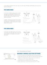
The professional unmanned aerial surveying solution is a strong alliance between the high-precision navigation industry and the commercial drone industry. With the powerful T300 Plus GNSS Receiver as the base station, this solution will provide easy workflow and centimeter-grade accuracy. GNSS Receiver (Build-in GNSS Module) Internal Memory To meet different demands of UAV users, there are 2 work modes, PPK Mode and RTK Mode, which can be also applied simultaneously. In this mode, UAV GNSS position can be corrected according to the base station RTCM data in real time. With T300 Plus WIFI link...
Open the catalog to page 2
The professional unmanned aerial surveying solution is a strong alliance between the high-precision navigation industry and the commercial drone industry. With the powerful T300 Plus GNSS Receiver as the base station, this solution will provide easy workflow and centimeter-grade accuracy. GNSS Receiver (Build-in GNSS Module) Internal Memory To meet different demands of UAV users, there are 2 work modes, PPK Mode and RTK Mode, which can be also applied simultaneously. In this mode, UAV GNSS position can be corrected according to the base station RTCM data in real time. With T300 Plus WIFI link...
Open the catalog to page 3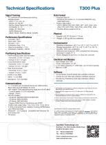
Technical Specifications Signal Tracking • Data Format 572 channels for simultaneously tracking satellite signals - GPS: L1, L2, L2C, L5 - BeiDou: B1, B2, B3 - BeiDou Global Signal: B1C, B2a - GLONASS: L1, L2 - Galileo: E1, E5a, E5b - QZSS (Reserved) - SBAS: WAAS, EGNOS, MSAS, GAGAN Cold start: <50 s Warm start: <30 s Hot start: <15 s Initialization time: <10 s Signal re-acquisition: <1.5 s Initialization reliability: >99.9% Operating temperature: -40 °C to + 65 °C (-40 °F to 149 °F) Storage temperature: -40 °C to + 85 °C (-40 °F to 185 °F) Humidity: 100% non-condensing Waterproof and dustproof:...
Open the catalog to page 4All ComNav Technology Ltd. catalogs and technical brochures
 LS600 Laser Scanner
2 Pages
 SinoGNSS Jupiter Laser RTK
2 Pages
 AT600 Chock Ring Antenna
1 Page
 M300 Pro 2023 GNSS Receiver
2 Pages
 K823 GNSS Module
2 Pages
 AT410 GNSS Antenna
2 Pages
 M900 GNSS Receiver
2 Pages
 U70 Datalink Module
1 Page
 N3 IMU GNSS Receiver
2 Pages
 AT360 Geodetic Antenna
1 Page
 P8 Tablet
2 Pages
 R60 Data Collector
2 Pages
 N2 GNSS Palm Receiver
2 Pages
 Mars Pro Laser RTK
2 Pages
 Mars Laser RTK
2 Pages
 Venus Laser RTK
2 Pages
 Sinognss P6H Hanheld
2 Pages
 M100X GNSS Receiver
2 Pages
 LS300 Laser Scanning
2 Pages
 Z30 Portable GNSS Receiver
2 Pages
 T30 IMU GNSS Receiver
2 Pages
 T20 Palm GNSS Receiver
2 Pages
 A100 Series Smart Antenna
2 Pages
 TS-C200 Total Station
2 Pages
 TS-C100 Total Station
2 Pages
 T300 GNSS Receiver_K8
2 Pages
 T300 Plus GNSS Receiver
2 Pages
 U50 Data Link Module
1 Page
 K726 GNSS OEM Board
2 Pages
 AT160 Helix Antenna
1 Page
 K706 GNSS OEM Board
2 Pages
 K708 GNSS OEM Board
2 Pages
 K705 GNSS OEM Board
2 Pages
 K803 GNSS Module
2 Pages
 K700 GNSS Board
2 Pages
 R200 Data Collector
2 Pages
 AT500 Chock Ring Antenna
1 Page
Archived catalogs
 AT190 Helix Antenna
1 Page
 AT340 Geodetic Antenna
1 Page
 R550 Data Collector
2 Pages
 R500 Data Collector
2 Pages
 G100 GNSS Receiver
2 Pages
 G200 GNSS Receiver
2 Pages
 M300 Plus GNSS Receiver
2 Pages
 T30 GNSS Receiver
2 Pages
 M300 Pro II GNSS Receiver
2 Pages
 T30 Surveying Solution
4 Pages
 T30 IMU Surveying Solution
4 Pages
 CDL5 External Data Link
2 Pages
 M10 Mini GNSS Receiver
2 Pages
 T300 Plus GNSS Receiver
2 Pages
 P300 Series
2 Pages
 N5 IMU GNSS Receiver
2 Pages

- Management software solution
- Windows software
- Real-time software
- Computer-aided design software
- Cloud-based software
- Touch screen tablet
- Wireless tablet
- Design software solution
- Rugged tablet
- Monitoring software solution
- Interface software
- Bluetooth tablet
- WiFi tablet
- GNSS tablet
- Automated software
- Industrial tablet
- Touch screen HMI
- Windows tablet
- Network software
- IP65 tablet