


RS10

RS10
- RTK and SLAM Fusion: The RS10 combines a 4th generation GNSS antenna with high-precision LiDAR and HD cameras, achieving RTK positioning accuracy better than 3 cm and absolute measurement accuracy of 5 cm.
- SFix Technology: Enables accurate RTK point coordinates calculation in areas with weak or no GNSS signals, ensuring 5 cm precision within 1 minute.
- Vi-LiDAR Technology: Offers a new mode of RTK surveying by combining GNSS rover capabilities with laser scanning for contactless offset measurements, achieving 5 cm accuracy within 15 m.
- Real-Time SLAM: Provides real-time georeferenced point clouds without post-processing, allowing for immediate data feedback and adjustments.
- Efficient Workflow: Eliminates the need for traditional loop closure, streamlining data collection and reducing project time and effort.
- GNSS Performance: Supports multiple satellite systems including BeiDou, GPS, QZSS, GLONASS, NavIC/IRNSS, and Galileo.
- Laser Scanner: Features a range capability of 0.05 to 120 m, with a maximum effective measurement rate of 320,000 points/sec.
- Camera: Equipped with three 15 MP cameras, providing high-resolution imaging.
- Environmental and Electrical: Operates in temperatures from -20°C to +60°C, with IP64 ingress protection and a hot-swappable battery system.
Catalog excerpts

RS10 INNOVATIVE SURVEYING SLAM SOLUTION MAPPING & GEOSPATIAL
Open the catalog to page 1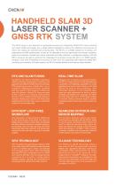
The RS10 brings a new approach to geospatial surveying by integrating GNSS RTK, laser scanning and visual SLAM technologies into a single platform designed to improve the efficiency and accuracy of indoor and outdoor 3D scanning and surveying tasks. The RS10 is a versatile solution for surveying, civil engineering and BIM professionals, as well as for applications such as agricultural and forestry surveying, power line inspection, material pile volume calculation and data collection in underground spaces. With the RS10, surveyors are able to overcome the challenges of surveying in areas with...
Open the catalog to page 2
ONE DEVICE, TWO WORKING WAYS Ready for RTK Users Operates in rover mode with CHCNAV LandStar™ software for easy use and minimal training. Hot-Swappable Battery Runs for 60 minutes on a single battery, allowing for easy replacement without powering off the unit. Precision Alert When used as a SLAM scanner, SmarGo provides real-time accuracy information for on-the-spot improvement. Automatic Drawings Using the CHCNAV software ecosystem, the RS10 data can be sent to CoProcess for instant drawing extraction.
Open the catalog to page 3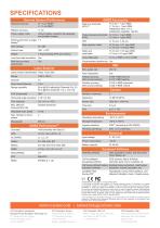
measurement rate Selectable scan speed 10 Hz GNSS Accuracies Real time kinematic H: 8 mm + 1 ppm RMS Initialization time: <10 s Initialization reliability: >99.9% Post-processing kinematic H: 3 mm + 1 ppm RMS Attitude accuracy 0.005° RMS pitch/roll, after post-processing 0.010° RMS heading Position accuracy 0.010 m RMS horizontal, after post-processing 0.020 m RMS vertical Ingress protection IP64(5) (according to IEC 60529) Humidity (operating) 80%, non-condensing SmartGo software Data acquisition control, real-time point cloud display, etc CoPre intelligent POS process, Adjust & Refine, processing...
Open the catalog to page 4All CHC Navigation | CHCNAV catalogs and technical brochures
 TX63
TX634 Pages
 H3
H34 Pages
 TD63 PRO
4 Pages
 CoProcess
4 Pages
 CoPre
CoPre4 Pages
 i73+ IMU RTK GNSS
4 Pages
 i83 GNSS Receiver
4 Pages
 i93
i934 Pages
 iBase_DS_EN
4 Pages
 i89
i894 Pages
 LT800
LT8004 Pages
 P330 PRO
4 Pages
 LT60H
LT60H4 Pages
 D270
D2704 Pages
 APACHE 3 Pro USV
4 Pages
 LT800H RTK
4 Pages
 AlphaAir 10
4 Pages
 AlphaUni 20
4 Pages
 C5 & C30
4 Pages
 CGI-610
4 Pages
 TG63
TG634 Pages
 NX510 SE
4 Pages
 HCE600
4 Pages
 LandStar 8
4 Pages
 CPS
CPS4 Pages
 CGO 2
CGO 24 Pages
 P5
P54 Pages
 DL8
DL84 Pages
 CTS-112R4
4 Pages
 P2 Elite
4 Pages
 P2
P24 Pages
 C220GR2
4 Pages
 AT312
AT3124 Pages
 NX510 PRO
4 Pages
 BB4 UAV
4 Pages
 Alpha3D
4 Pages
 AlphaUni 900/1300
4 Pages
 AlphaAir 450
4 Pages
 APACHE6
4 Pages
 Apache4
4 Pages
 Apache 3
4 Pages
 AlphaAir 1400-2400
4 Pages
 D390_DS_EN
4 Pages
 D230_DS_EN
4 Pages
- Flowmeter
- Liquid flow monitor
- Management software solution
- Data logger
- Analysis software solution
- Windows software
- Cloud-based software
- USB camera module
- Touch screen tablet
- Wireless tablet
- Rugged tablet
- 3D software solution
- Inspection imager
- Water flow monitor
- Bluetooth tablet
- WiFi tablet
- Wireless datalogger
- GNSS tablet
- Industrial tablet
- Datalogger without display