LT800
1 /4Pages

LT800
1 /4Pages
Catalog excerpts

RUGGED GNSS TABLET MAPPING & GEOSPATIAL
Open the catalog to page 1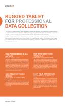
The LT800 is a rugged Android™ tablet designed to increase the efficiency and productivity of mobile workforce in applications that require meter-level GNSS positioning and uninterrupted performance. Portable, rugged and versatile, it enables GIS data collection, environmental surveys, landscaping and other scenarios. Its 8.1" sunlight-readable display makes it easy to view GIS data tables, complex vector and raster maps, and high-resolution images clearly, even in direct sunlight and brightly lit areas. Its IP67-rated industrial design enables it to withstand daily use in harsh environments...
Open the catalog to page 2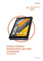
Aproffessional RUGGED TABLET
Open the catalog to page 3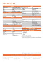
Physical Operating system Network 4G modem (Built in 4G modem) Dust and water proof IP67 Shock 1.2 m fall onto concrete (without condensation) Size 215.5 mm x 130 mm x 14.5 mm Weight 550 g (19.4 oz) with battery GSM:B2/B3/B5/B8 WCDMA: B1/B2/B4/B5/B8/B19 CDMA EVDO: BCO TD-SCDMA:B34/B39 LTEFDD: B1/B2/B3/B4/B5/B7/B8/ B12/B17/B18/B19/B20/B26/B28 LTE TDD: B34/B38/B34/B39/B40/ B41 SIM card type Dual nano SIM card Internal sensors NFC; G-Sensor; Light Sensor; E-Compass; Gyroscope Accessories Fast charging: QC 3.0 - Screen protector - Packaging box - Stylus - Type-C USB cable - Charger * All specifications...
Open the catalog to page 4All CHC Navigation | CHCNAV catalogs and technical brochures
 RS10
RS104 Pages
 TX63
TX634 Pages
 H3
H34 Pages
 TD63 PRO
4 Pages
 CoProcess
4 Pages
 CoPre
CoPre4 Pages
 i73+ IMU RTK GNSS
4 Pages
 i83 GNSS Receiver
4 Pages
 i93
i934 Pages
 iBase_DS_EN
4 Pages
 i89
i894 Pages
 P330 PRO
4 Pages
 LT60H
LT60H4 Pages
 D270
D2704 Pages
 APACHE 3 Pro USV
4 Pages
 LT800H RTK
4 Pages
 AlphaAir 10
4 Pages
 AlphaUni 20
4 Pages
 C5 & C30
4 Pages
 CGI-610
4 Pages
 TG63
TG634 Pages
 NX510 SE
4 Pages
 HCE600
4 Pages
 LandStar 8
4 Pages
 CPS
CPS4 Pages
 CGO 2
CGO 24 Pages
 P5
P54 Pages
 DL8
DL84 Pages
 CTS-112R4
4 Pages
 P2 Elite
4 Pages
 P2
P24 Pages
 C220GR2
4 Pages
 AT312
AT3124 Pages
 NX510 PRO
4 Pages
 BB4 UAV
4 Pages
 Alpha3D
4 Pages
 AlphaUni 900/1300
4 Pages
 AlphaAir 450
4 Pages
 APACHE6
4 Pages
 Apache4
4 Pages
 Apache 3
4 Pages
 AlphaAir 1400-2400
4 Pages
 D390_DS_EN
4 Pages
 D230_DS_EN
4 Pages
- Flowmeter
- Liquid flow monitor
- Management software solution
- Data logger
- Analysis software solution
- Windows software
- Cloud-based software
- Touch screen tablet
- USB camera module
- Wireless tablet
- 3D software solution
- Bluetooth tablet
- Water flow monitor
- WiFi tablet
- Inspection imager
- Wireless datalogger
- Industrial tablet
- Rugged camera