
- Catalogs
- CHC Navigation | CHCNAV
- AlphaUni 20


AlphaUni 20

AlphaUni 20
- Outstanding Accuracy: Utilizes a high-precision navigation algorithm with a repeated ranging accuracy of 5 mm and absolute accuracy of 2 to 5 cm.
- Multi-Platform Design: Can be mounted on various platforms including drones, helicopters, airplanes, cars, boats, trains, and backpacks.
- Strong Penetration: Supports up to 16 target echoes for superior vegetation penetration, aiding in the creation of accurate Digital Elevation Models (DEMs) and Digital Surface Models (DSMs).
- Premium Laser: Offers long-range capabilities up to 1450 m and high-speed scanning at 2 million points per second.
- Industrial Reliability: Designed to perform reliably in diverse environmental conditions.
- Light-Weight and Highly Integrated: Weighs only 2.82 kg, with easy installation facilitated by Alphaport's one-click connection.
- Efficient Workflow: Supported by SmartGo software for real-time mission monitoring and CoPre desktop software for intelligent point cloud processing.
- Airborne Setup: Easily installed on aerial platforms with a payload capacity of up to 2.6 kg.
- Vehicle Setup: Quick switch to vehicle mode in 5 minutes, compatible with various car types.
- Backpack Survey: Suitable for narrow streets or steep slopes where vehicles and drones are impractical.
- Weight: 2.82 kg (without camera), 3.12 kg (with C5 camera).
- Resolution: 45 MP with optional 512 GB or 1 TB data storage.
- Operating Temperature: -20°C to +50°C.
- IP Rating: IP64 for environmental protection.
- GNSS System: Supports multiple constellations including GPS, GLONASS, Galileo, BeiDou, SBAS, and QZSS.
- Power Consumption: 60 W with an input voltage range of 15 - 27 V.
Catalog excerpts

MULTI-PLATFORM HIGH-END LiDAR SOLUTIONS MAPPING & GEOSPATIAL
Open the catalog to page 1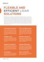
FLEXIBLE AND EFFICIENT LIDAR SOLUTIONS The AlphaUni 20 is a cost-effective and multi-platform mobile mapping system. It is the result of six years of innovation and product development powered by CHCNAV's state-of-the-art LiDAR technology. In airborne scenarios, the AU20 delivers superior data and improves survey efficiency thanks to its exceptional vegetation penetration capability, extended measurement range, high accuracy, and data density. The AU20's unique, flexible installation design, coupled with CHCNAV's LiDAR technology, ensures the best combination of point cloud density, accuracy,...
Open the catalog to page 2
MOST FLEXIBLE INSTALLATION Airborne setup Simple vehicle setup Backpack survey AU20 can be easily installed on any aerial platform (drone, helicopter, or airplane) with payload capacity of up to 2.6 kg. For road measurements and special tasks, switching to vehicle mode takes just 5 minutes, regardless of car type. Practical mobile mapping system combining accurate LiDAR data with immersive panoramic imagery and SLAM. The backpack setup enables survey in narrow streets or on steep slopes, where cars cannot go, and drones cannot fly.
Open the catalog to page 3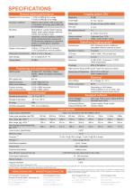
General system performance Absolute Hz & V accuracy Accuracy conditions Without control points, UAV survey with 7 m/s speed, car survey wihout DMI with 9.7 m/s speed Multi-platform, quickly install & release design, easily switch between airborne, vehicle and backpack mode AlphaPano vechicle installation platform which include panoramic camera and SLAM scanner integration for optimised position in challenging for trajectory environment Focal length Sensor size Pixel size Airborne optional camera setup AlphaPano Imaging system Camera type 2.82 kg / 3.12 kg (with C5 camera) 10.97 kg AlphaPano vechicle...
Open the catalog to page 4All CHC Navigation | CHCNAV catalogs and technical brochures
 RS10
RS104 Pages
 TX63
TX634 Pages
 H3
H34 Pages
 TD63 PRO
4 Pages
 CoProcess
4 Pages
 CoPre
CoPre4 Pages
 i73+ IMU RTK GNSS
4 Pages
 i83 GNSS Receiver
4 Pages
 i93
i934 Pages
 iBase_DS_EN
4 Pages
 i89
i894 Pages
 LT800
LT8004 Pages
 P330 PRO
4 Pages
 LT60H
LT60H4 Pages
 D270
D2704 Pages
 APACHE 3 Pro USV
4 Pages
 LT800H RTK
4 Pages
 AlphaAir 10
4 Pages
 C5 & C30
4 Pages
 CGI-610
4 Pages
 TG63
TG634 Pages
 NX510 SE
4 Pages
 HCE600
4 Pages
 LandStar 8
4 Pages
 CPS
CPS4 Pages
 CGO 2
CGO 24 Pages
 P5
P54 Pages
 DL8
DL84 Pages
 CTS-112R4
4 Pages
 P2 Elite
4 Pages
 P2
P24 Pages
 C220GR2
4 Pages
 AT312
AT3124 Pages
 NX510 PRO
4 Pages
 BB4 UAV
4 Pages
 Alpha3D
4 Pages
 AlphaUni 900/1300
4 Pages
 AlphaAir 450
4 Pages
 APACHE6
4 Pages
 Apache4
4 Pages
 Apache 3
4 Pages
 AlphaAir 1400-2400
4 Pages
 D390_DS_EN
4 Pages
 D230_DS_EN
4 Pages
- Flowmeter
- Liquid flow monitor
- Management software solution
- Data logger
- Analysis software solution
- Windows software
- Cloud-based software
- USB camera module
- Touch screen tablet
- Wireless tablet
- Rugged tablet
- 3D software solution
- Inspection imager
- Water flow monitor
- Bluetooth tablet
- WiFi tablet
- Wireless datalogger
- GNSS tablet
- Industrial tablet
- Datalogger without display