
- Catalogs
- CHC Navigation | CHCNAV
- AlphaAir 10


AlphaAir 10

AlphaAir 10
The AlphaAir 10 (AA10) is a professional airborne LiDAR and RGB system designed for UAV LiDAR mapping and drone photogrammetry. It integrates high-precision LiDAR, GNSS positioning, IMU orientation, and a full-frame orthophoto camera, providing a cost-effective solution for 3D data acquisition and processing.
The AA10 offers high-precision navigation with 5 mm repeated range accuracy and 2 to 5 cm absolute precision. It features enhanced vegetation penetration with up to 8 target echoes, allowing for accurate Digital Elevation Models (DEMs) and Digital Surface Models (DSMs) in dense environments. The system supports long-range measurements up to 800 m and rapid scanning at 500,000 points per second.
The AA10 is lightweight (1.55 kg) and compact, designed for easy integration with various UAVs. It supports real-time data visualization and automated reality capture. The CoPre and CoProcess software suite streamlines post-processing and feature extraction, enhancing workflow efficiency.
- Dimensions: 210 mm x 112 mm x 131 mm
- Weight: 1.55 kg
- Operating time: 30 minutes
- IP64 rating for weather resilience
- Positioning: GPS, GLONASS, BEIDOU, GALILEO
- Laser classification: Class 1
- Max measurement rate: 500,000 meas/sec
- Operating temperature: -20°C to +50°C
The AA10 includes a 45 MP full-frame camera with a 21 mm focal length, providing high-resolution image mapping textures for 3D model reconstruction. The system supports a minimum photo interval of 1 second.
CHCNAV's CoPre software handles essential processing steps, while the Alphaport interface provides wireless power and telemetry connectivity. The system is compatible with various UAV platforms, including DJI Matrice.
CHC Navigation has offices in China, Europe, USA, and India, providing global support and services.
Catalog excerpts

PROFESSIONAL AIRBORNE LiDAR+RGB SYSTEM MAPPING & GEOSPATIAL
Open the catalog to page 1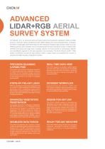
ADVANCED LIDAR+RGB AERIAL SURVEY SYSTEM The AlphaAir 10 is an advanced aerial surveying solution that seamlessly integrates LiDAR and RGB sensors to meet the needs of professional UAV LiDAR mapping and drone photogrammetry. Leveraging CHCNAV's cutting-edge LiDAR technology, the AA10 flawlessly integrates high-precision LiDAR, accurate GNSS positioning, IMU orientation and an industrial-grade full-frame orthophoto camera. Combined with CHCNAV point cloud and image fusion modeling software, the AA10 provides a survey-grade, efficient and cost-effective approach to 3D data acquisition and processing....
Open the catalog to page 2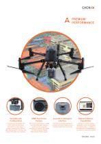
PREMIUM PERFORMANCE Innovative Alphaport Interface Robust Software Capabilities Compact and lightweight, the AA10 LiDAR can be easily mounted on a wide range of drones, including the CHCNAV BB4, the popular DJI Matrice, and various third-party UAV platforms. The AA10’s high-precision LiDAR and industrial-grade cameras enable users to generate accurate and realistic 3D models and high-resolution Digital Orthomosaic (DOM) outputs. CHCNAV's exclusive Alphaport interface provides wireless power and drone telemetry connectivity. CHCNAV's CoPre software efficiently handles all essential processing...
Open the catalog to page 3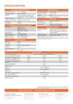
SPECIFICATIONS General system performance Operating temperature Mounting Weight of instrument Dimensions of instrument Data storage Coping speed Electrical Input voltage Power consumption Power source Positioning and orientation system GNSS system Humidity (operating) Quickly install & release design, easily switch between various UAV platforms Storage temperature Depending on UAV battery or by Skyport (DJI M300/M350) Equipped software Position accuracy after post-processing Terrain module, road module, extraction module, volume module Data copy, POS solve, point cloud and images creation, strip...
Open the catalog to page 4All CHC Navigation | CHCNAV catalogs and technical brochures
 RS10
RS104 Pages
 TX63
TX634 Pages
 H3
H34 Pages
 TD63 PRO
4 Pages
 CoProcess
4 Pages
 CoPre
CoPre4 Pages
 i73+ IMU RTK GNSS
4 Pages
 i83 GNSS Receiver
4 Pages
 i93
i934 Pages
 iBase_DS_EN
4 Pages
 i89
i894 Pages
 LT800
LT8004 Pages
 P330 PRO
4 Pages
 LT60H
LT60H4 Pages
 D270
D2704 Pages
 APACHE 3 Pro USV
4 Pages
 LT800H RTK
4 Pages
 AlphaUni 20
4 Pages
 C5 & C30
4 Pages
 CGI-610
4 Pages
 TG63
TG634 Pages
 NX510 SE
4 Pages
 HCE600
4 Pages
 LandStar 8
4 Pages
 CPS
CPS4 Pages
 CGO 2
CGO 24 Pages
 P5
P54 Pages
 DL8
DL84 Pages
 CTS-112R4
4 Pages
 P2 Elite
4 Pages
 P2
P24 Pages
 C220GR2
4 Pages
 AT312
AT3124 Pages
 NX510 PRO
4 Pages
 BB4 UAV
4 Pages
 Alpha3D
4 Pages
 AlphaUni 900/1300
4 Pages
 AlphaAir 450
4 Pages
 APACHE6
4 Pages
 Apache4
4 Pages
 Apache 3
4 Pages
 AlphaAir 1400-2400
4 Pages
 D390_DS_EN
4 Pages
 D230_DS_EN
4 Pages
- Flowmeter
- Liquid flow monitor
- Management software solution
- Data logger
- Analysis software solution
- Windows software
- Cloud-based software
- USB camera module
- Touch screen tablet
- Wireless tablet
- Rugged tablet
- 3D software solution
- Inspection imager
- Water flow monitor
- Bluetooth tablet
- WiFi tablet
- Wireless datalogger
- GNSS tablet
- Industrial tablet
- Datalogger without display