- Catalogs
- Carlson Software
- Solutions for Land Development Professionals
Solutions for Land Development Professionals
1 /24Pages

Solutions for Land Development Professionals
1 /24Pages
Catalog excerpts

Office Software Data Collection Instruments Survey & GIS Civil Engineering Construction Accident Reconstruction Solutions for Land Development Professionals
Open the catalog to page 1
Carlson Software produces a complete suite of solutions for land development professionals, across the disciplines of data collection, surveying, engineering design and drafting. In addition, utilizing its expertise in data collection, Carlson also offers accident and crime reconstruction field and office software for law enforcement personnel or law consultants. We at Carlson recognize the paramount importance of free choice to the professional consumer in the land industry. We are committed to providing consistent software interfaces across hardware and across disciplines. This is the mission...
Open the catalog to page 2
Carlson Works for You Carlson Software encourages a “positive feedback loop” from our customers ensuring that our annual software releases are full of customer-driven new features. We are grateful for our high rate of customer retention over our history and firmly believe in providing free technical support, which Carlson has done since the day of its founding. “With RoadNETwork [in Carlson Civil], you can grip/ edit a centerline and have the whole thing seamlessly and dynamically update. That is the coolest thing I’ve experienced in the software.” “Carlson, with their hardware and their software,...
Open the catalog to page 3
Carlson iCAD / Carlson Survey Carlson iCAD Carlson Survey Simple but Powerful CAD solution Surveyors’ #1 Software Choice Carlson iCAD is an affordable CAD program that is .dwg file based and designed to fit into your production workflow. Carlson iCAD allows drafters to finish drawings and engineers to review drawings. ■ Get full tool kit – everything from network least squares to surface modeling ■ Work seamlessly between office and field ■ Establish company-wide design styles ■ Create GIS links & exchange Esri® data Basic Features: 2D and 3D CAD package Based on .dwg, .dng file Built on IntelliCAD®...
Open the catalog to page 4
Carlson SurveyGNSS Carlson Point Cloud Carlson commands, Microstation© platform For all your Post-Processing needs Bring Point Cloud data to the world of CAD A Windows-based coordinate geometry program, Simplicity provides simplified methods for solving commonly encountered Designed for surveyors and positioning Carlson Survey Carlson Simplicity Sight Survey A modular program that provides the ability to go from field scan to finished plat, Carlson Point Cloud delivers powerful automation coordinate geometry and construction surveying problems. Simplicity works with: ■ AutoCAD® ■ IntelliCAD®...
Open the catalog to page 5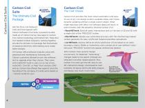
Carlson Civil Suite Carlson Civil Suite Carlson Civil The ‘Civil’ Choice The Ultimate Civil Package Get Fair Price, Full Featured CAD, and Free Support with Carlson Software’s Civil Suite, a powerful bundle made up of: Carlson Survey (see page 4), Carlson Civil, Carlson Hydrology, and Carlson GIS. These four civil-related modular programs, working together, provide the ultimate civil package that dramatically increases productivity while helping users create better designs. All Carlson office software modules come with perpetual and maintenance licensing with Carlson customers allowed to own...
Open the catalog to page 6
Complete Hydrologic & Hydraulic Solution Comprehensive, yet easy-to-master, Carlson Hydrology provides the automation to meet your hydrology needs and all in the CAD environment of polylines, text, and layers. Full 3D road and lot design feed directly into flow calculations and drainage design. Top attributes include: ■ Site Drainage-using either Rational or SCS Method ■ Runoff Analysis to determine watershed area, time of concentration and peak flow rates ■ Storm Drain System design and drafting ■ Pond, culvert, channels, and outlet design and sizing ■ Extensive libraries on rainfall, inlets,...
Open the catalog to page 7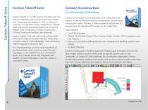
Carlson Takeoff Suite Carlson Takeoff Suite For Estimating & 3D Modeling Carlson Takeoff is a cut/fill volumes and data prep (for layout or machine control) solution that can estimate jobs using paper plan digitizing, PDFs, or electronic CAD files. It is available in two configurations--Takeoff OEM (comes with AutoCAD engine built-in) and the Takeoff Suite, comprised of Carlson Construction, CADnet, Trench, and GeoTech (see following). Carlson Takeoff is the only estimating software that works in the .dwg environment natively, which gives its users a distinct “CAD Advantage” when estimating from...
Open the catalog to page 8
Carlson Trench Carlson GeoTech Create CAD from PDF, BIM, and more For Trench Quantities & Modeling Know your Strata Cut Carlson Trench is for calculations related to installing pipes, sewers, or utility lines. The software calculates the volume of the trench cut, the volume of backfill (excluding pipe size), and the linear footage of pipe broken down by the pipe material, size, and/or depth. Designed for geotechnicians, civil engineers, and construction professionals, Carlson GeoTech provides the ability to import borehole data for analyzing subsurface conditions and materials. It models all...
Open the catalog to page 9
Carlson Photo Capture Carlson Photo Capture Surveyors, Meet the Newest Tool in Your Kit Aerial surveying is rapidly becoming a vital part of any surveyor’s toolkit. Thousands of people use drone site flyovers every day to help boost efficiency and lower costs. With Carlson Photo Capture processing, you can use flyover data to: Instantly generate interactive 3D maps of sites Capture highly accurate 3D site data from any camera Share site maps with customers -anywhere, anytime! Save man-hours in the field Available in both cloud-based and standalone desktop versions, PhotoCapture meets the needs...
Open the catalog to page 10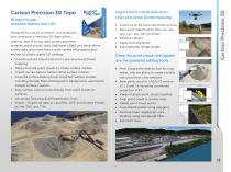
Bridge the gap between drones and CAD Designed for use by surveyors, civil engineers, and contractors, Precision 3D Topo allows users to import survey data, points, polylines, surfaces, point clouds, both traditional LIDAR and aerial drone survey data, and more from a wide variety of programs and entities to create usable 3D surfaces. ■ Importing Point Cloud data from Lidar and Aerial Drone mapping. Import Point Cloud data from Lidar and Aerial Drone mapping. ■ Import up to 50 point cloud files at once ■ Bare earth classification filter .las, .laz, .ply, .xyz, .pts, .e57, .pcd files ■ Remove...
Open the catalog to page 11- Automation software solution
- Management software solution
- Analysis software solution
- Measuring machine
- Process software
- Windows software
- Real-time software
- Computer-aided design software
- Cloud-based software
- Control software
- Touch screen tablet
- Wireless tablet
- Design software solution
- Rugged tablet
- Monitoring software solution
- 3D software solution
- Measurement software
- Quality software
- GNSS tablet
- Simulation software solution