- Catalogs
- Bentley Systems Europe B.V.
- Skand Delivers Integrated 3D Model and Asset Lifecyle Program for a University Campus
- Products
- Catalogs
- News & Trends
- Exhibitions
Skand Delivers Integrated 3D Model and Asset Lifecyle Program for a University Campus
1 /2Pages

Skand Delivers Integrated 3D Model and Asset Lifecyle Program for a University Campus
1 /2Pages
Catalog excerpts
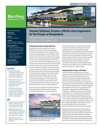
CASE STUDY Project Summary Organization Skand Pty. Ltd. Solution Reality Modeling Location Victoria, Australia Project Objectives • To provide integrated drone imagery into an asset lifecycle platform for unbiased analysis. • To deliver a superior quality model and defect mapping for better asset maintenance. Products Used ContextCapture Fast Facts • Skand was tasked with conducting an urban capture of RMIT’s Brunswick campus. • Skand used its web application, supported by ContextCapture, to integrate drone imagery and analysis into an ISO-certified asset lifecycle program. • ContextCapture allowed Skand to project thermal defects, such as thermal signatures and water leaks, onto a high-resolution 3D model. ROI • ContextCapture allowed building envelope inspection to occur nearly four times faster than with previously used photogrammetry engines. • Skand delivered an inspection report and 3D campus model within seven days at AUD 80,000, significantly less than the AUD 150,000 budget. • Skand expects the AI anaylsis time to be reduced to 72 hours from data acquisition to report. Skand Delivers Integrated 3D Model and Asset Lifecyle Program for a University Campus ContextCapture Sped-up the Project Four Times Faster, Saving AUD 70,000 Integrating Drone Data and Analysis into Asset Lifecycle Program Skand Pty. Ltd., a Melbourne-based start-up, was tasked with conducting an urban capture of the Royal Melbourne Institute of Technology’s (RMIT) Brunswick campus. The Australian public research university wanted to integrate drone data capturing and analysis into its award-winning 40-year asset lifecycle program, which is ISO certified. The university’s portfolio includes 74.4 hectares of land and many historical buildings. Managing these physical assets is a core business activity and integral to extending their life. To better manage the assets, RMIT wanted to create a digital version of its Brunswick campus, updating the previously 2D orthophoto representation. The AUD 150,000 project area covers 6.5 hectares and six buildings of various sizes and building material types, which would all be incorporated into the RMIT asset lifecycle program. Founded in 2018 with less than 10 employees, Skand specializes in building envelope solutions for its clients. The project team wanted to provide RMIT with a platform to integrate drone imagery into their asset lifecycle program, as well as to deliver a superior quality of model and defect mapping for better asset maintenance planning. Skand needed to conduct an unbiased analysis of the site that included layers of categorization and integrated with an ISOcompliant asset management system. allow for easy collaboration between users, allowing people to work together to add extra layers of information to the models. Finally, the project team members have varying levels of experience; some team members are recent high school graduates while others have years of experience working on these kinds of projects. The centralized cloud-based viewing platform needed to be intuitive and easy enough to navigate for people of all experience levels. Creating 3D Images from 2D Data Skand used a Phantom 4 Pro drone to capture imagery of the project site, conducting three passes with the drone. Each pass would be closer to the asset until it was as low as legally possible. Skand then used its web application, supported by ContextCapture, to integrate the drone imagery and analysis into the ISO-certified asset lifecycle program. This web application is specifically designed for asset owners and asset managers, meeting and exceeding RMIT’s building envelope inspection project brief. Skand chose Bentley as the support for this platform because of its technical knowledge, active support team, and scalability of working with cloud services. Overcoming Location and Access Challenges The main challenge on this project was site access. Australia has many regulations on having drones in the air among people and infrastructure, which only allowed for a short window of time that Skand could use the drones at the university. Additionally, many of the buildings were near roads, and the drones could not pass over a road. As a result, Skand needed to develop a different method of capturing data. Other challenges came from the people who needed to access the platform. The platform had to be homogenous so that everyone accessing the data was viewing the same information, regardless of their location. It also needed to Skand projects AI-identified defects onto the ContexCapture reality mesh including forms of corrosion and building
Open the catalog to page 1
"Skand & Bentley partnership enables productivity & efficiency in the asset management workflow. Using Skand's cutting edge machine learning technology & adopting a proactive approach will reduce OPEX compared to traditional inspection methods." - Yossi Kahlon, CEO, Skand Find out about Bentley at: www.bentley.com Contact Bentley 1-800-BENTLEY (1-800-236-8539) Outside the US +1 610-458-5000 Global Office Listings www.bentley.com/contact ContextCapture allowed the Skand solution to take in aerial-and land-based 2D images and turn them into meaningful data sets mapped in a 3D reality mesh. This...
Open the catalog to page 2All Bentley Systems Europe B.V. catalogs and technical brochures
 Digital Airport Project Showcase
18 Pages
 Water_Hazelwood_Coal_Mine
2 Pages
 Water_Simtejo_case_study
2 Pages
 Wimbledon Stadium_Case Study
2 Pages
 WSP-Shard_Case_Study
3 Pages
 Bentley’s Water Project Showcase
92 Pages
 Mine Water Software Solution
4 Pages
 AutoPLANT Equipment V8i
2 Pages
 AutoPLANT Piping V8i
2 Pages
 ConstructSim
2 Pages
 promis•e
2 Pages
 Bentley Datasheets
2 Pages
 Making PDS Interoperable
17 Pages
 Bentley OpenPlant PowerPID
2 Pages
 STAAD.Pro
2 Pages


Archived catalogs
 Water modelling
24 Pages
 Bentley Water V8 XM
2 Pages
 Bentley Cadastre Specsheet
2 Pages
 STAAD Foundation
2 Pages
 RAM CADStudio
2 Pages
 Bentley MAP
2 Pages
 Bentley Structural Brochure
2 Pages
 Bentley Project Yearbook 2006
82 Pages
 Bentley SewerCAD
2 Pages
 Bentley WaterCAD
2 Pages
 Bentley WaterGEMS
2 Pages
 Bentley HAMMER
2 Pages
 Bentley StormCAD
2 Pages
 Bentley SewerGEMS
2 Pages
 Bentley AutoPlant P&ID
2 Pages
 Bentley Microstation
2 Pages
 Bentley Architecture
2 Pages
 Bentley ProjectWise brochure
2 Pages
 Bentley CivilStorm
2 Pages
 Bentley ProjectWise
4 Pages
 Bentley PowerDraft
2 Pages
 Bentley AutoPipe Specsheet
2 Pages


- Automation software solution
- Management software solution
- Analysis software solution
- Process software
- Windows software
- Real-time software
- Computer-aided design software
- Cloud-based software
- Control software
- Design software solution
- 3D software solution
- Industrial software
- Interface software
- Visualization software solution
- Quality software
- Simulation software solution
- Automated software
- Programming software
- Development software
- Network software