- Catalogs
- Bentley Systems Europe B.V.
- RealWorld Engineering Consultants Created 3D GIS Models of a 1,000-Hectare Area of New Taipei City
- Products
- Catalogs
- News & Trends
- Exhibitions
RealWorld Engineering Consultants Created 3D GIS Models of a 1,000-Hectare Area of New Taipei City
1 /2Pages

RealWorld Engineering Consultants Created 3D GIS Models of a 1,000-Hectare Area of New Taipei City
1 /2Pages
Catalog excerpts
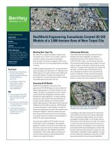
CASE STUDY Bentley Advancing Infrastructure Project Summary Organization RealWorld Engineering Consultants Solution Reality Modeling Location New Taipei City, Taipei, Taiwan Project Objectives • Survey a 1,000-hectare area of New Taipei City in Taipei, Taiwan and produce a 3D reality mesh of the area using a combination of photos and point clouds. Products Used ContextCapture RealWorld Engineering Consultants Created 3D GIS Models of a 1,000-hectare Area of New Taipei City Bentley's ContextCapture Improved Collaboration to Save 90 Percent of Total Project Time Fast Facts • RealWorld used ContextCapture to create 3D GIS models by gathering geographic information from aerial photos and point clouds. • ContextCapture helped create better models to improve collaboration among the various disciplines and project stakeholders. The use of ground-based LiDAR with ContextCapture increased model accuracy by 20 to 30 percent. The project team saved 90 percent of the total project time compared to traditional methods. ContextCapture reduced the project cost of completing the 3D model construction by nearly 80 percent. Modeling New Taipei City New Taipei City is a special municipality in Taipei and the most populous city in Taiwan. The city includes a stretch of the island's coastline and surrounds the Taipei Basin. Known as Taipei County before its upgrade in 2010, the city surrounds Taipei and is the second largest special municipality in the area. RealWorld Engineering Consultants Inc. was commissioned to survey and produce a 3D reality mesh of a 1,000-hectare area of New Taipei City. The region includes at least 4,000 houses and multiple buildings. The project was completed at the end of August 2017, and the mesh will be used for follow-up urban design planning and review of the city. Generating 3D GIS Models RealWorld was responsible for the entirety of the approximately USD 265,000 project, from aerial photos and oblique image acquisition to 3D model building at the later stages of the project. The organization was also in charge of delivering the final 3D geographic information system (GIS) platform analysis applications. The project produced high-precision, high-resolution, 3D urban models that will be used as the basic drawings for the follow-up 3D GIS platform planning analysis. These models will also help build 1,000 hectares of 3D models and provide a 3D GIS platform for relevant employees to conduct analyses. The area that needed to be documented was sizable, which posed the main challenge for RealWorld. Traditional methods would have been arduous and time consuming with so many buildings, but the project team met its deadline using ContextCapture, Bentley's 3D reality modeling technology. The project team created the 3D GIS models of the area in New Taipei City with ContextCapture. Users gathered geographic information of the area from aerial photos and point clouds using a wide variety of cameras and input the data into the application. Then, RealWorld implemented ContextCapture, which natively supports several types of positioning data to produce accurate georeferenced 3D models in a full range of GIS formats. Collaborating Effectively These models improved collaboration among the various disciplines and project stakeholders. The application generated many common 3D GIS platform formats, such as OBJ, DAE, KML, Cesium, and other formats often used. These formats are popular among users throughout the world, making it simple to transfer data in different formats to other design units. The project team could easily share models with each other, no matter the type of 3D GIS platform format. Also, ContextCapture allowed for easy measurement and analysis of model data. The team could save time getting accurate answers by performing precise measurements of distances, volumes, and surface areas directly in the model. 3D reality mesh of NewTaipei City with geographic information from aerial photos and point clouds ContextCapture also helped create better 3D model results, which RealWorld then shared with its project stakeholders. When using traditional imaging methods, such as airborne photography and oblique images, to build models, there are often portions of the model that are not visible. This situation is common when there are places where aerial surveys are obstructed. However, ContextCapture can be combined with ground-based LiDAR and aerial photography to produce high-precision models that avoid those holes. The team also used ContextCaptures high-fidelity imaging capabilities to support precision mapping and engineering, ensuring that all models were visibly accurate for the teams project stakeholders.
Open the catalog to page 1
"ContextCapture software can quickly build high-precision, high-resolution 3D models and quickly complete 1,000 hectares of 3D model building within a month." - Seager Peng, Aerial Survey Manager, RealWorld Engineering Consultants Doing More in Less Time The project team could use one-tenth of the labor usually required for the manual geometric method to build 3D models. This statistic is impressive because the target area of the 3D models was more than 10 times larger than the target area used with the traditional method, and it was completed during the same timeframe. Compared to traditional...
Open the catalog to page 2All Bentley Systems Europe B.V. catalogs and technical brochures
 Digital Airport Project Showcase
18 Pages
 Water_Hazelwood_Coal_Mine
2 Pages
 Water_Simtejo_case_study
2 Pages
 Wimbledon Stadium_Case Study
2 Pages
 WSP-Shard_Case_Study
3 Pages
 Bentley’s Water Project Showcase
92 Pages
 Mine Water Software Solution
4 Pages
 AutoPLANT Equipment V8i
2 Pages
 AutoPLANT Piping V8i
2 Pages
 ConstructSim
2 Pages
 promis•e
2 Pages
 Bentley Datasheets
2 Pages
 Making PDS Interoperable
17 Pages
 Bentley OpenPlant PowerPID
2 Pages
 STAAD.Pro
2 Pages


Archived catalogs
 Water modelling
24 Pages
 Bentley Water V8 XM
2 Pages
 Bentley Cadastre Specsheet
2 Pages
 STAAD Foundation
2 Pages
 RAM CADStudio
2 Pages
 Bentley MAP
2 Pages
 Bentley Structural Brochure
2 Pages
 Bentley Project Yearbook 2006
82 Pages
 Bentley SewerCAD
2 Pages
 Bentley WaterCAD
2 Pages
 Bentley WaterGEMS
2 Pages
 Bentley HAMMER
2 Pages
 Bentley StormCAD
2 Pages
 Bentley SewerGEMS
2 Pages
 Bentley AutoPlant P&ID
2 Pages
 Bentley Microstation
2 Pages
 Bentley Architecture
2 Pages
 Bentley ProjectWise brochure
2 Pages
 Bentley CivilStorm
2 Pages
 Bentley ProjectWise
4 Pages
 Bentley PowerDraft
2 Pages
 Bentley AutoPipe Specsheet
2 Pages


- Management software solution
- Automation software solution
- Analysis software solution
- Process software
- Windows software
- Real-time software
- Computer-aided design software
- Cloud-based software
- Control software
- Design software solution
- 3D software solution
- Industrial software
- Interface software
- Quality software
- Visualization software solution
- Simulation software solution
- Automated software
- Programming software
- Development software
- Network software