- Catalogs
- Bentley Systems Europe B.V.
- Philadelphia City Saves USD 30,000 by using ProjectWise Geospatial Management
- Products
- Catalogs
- News & Trends
- Exhibitions
Philadelphia City Saves USD 30,000 by using ProjectWise Geospatial Management
1 /2Pages

Philadelphia City Saves USD 30,000 by using ProjectWise Geospatial Management
1 /2Pages
Catalog excerpts

CASE STUDY Project Summary Organization Philadelphia Water Department Solution Government Location Philadelphia, Pennsylvania, United States Project Objectives • Implement ProjectWise Geospatial Management to extend document searchability. • Integrate ProjectWise data with the existing Esri geodatabase. • Integrate the geospatial database with the Capital Program Integrated Tracking database. Products Used Bentley Map, ProjectWise, ProjectWise Geospatial Management, MicroStation ProjectWise Geospatial Management Extends Searchability of Philadelphia Water Documents City Saves USD 30,000 Whenever ProjectWise CAD File is Located and Reused Rather than Recreated Geospatial Data Integration The Philadelphia Water Department (PWD) is a municipal utility providing a population of nearly 1.7 million people in three eastern Pennsylvania counties with integrated water, wastewater, and stormwater services. The utility is responsible for planning, design, construction, operation, and maintenance of the necessary infrastructure. By integrating the rapidly growing ProjectWise data management system with the city’s geospatial database and Capital Program Integrated Tracking (CAPIT) database, the department improved the ability to search for and locate CAD files and construction photos. The USD 65,000 project significantly reduced the expense of recreating lost CAD files, which cost roughly USD 30,000 to produce. Fast Facts • A basemap was created using GIS-to-CAD translations from Bentley Map. • CAD files without the proper coordinate system were geocoded using 1,700 geospatially correct ProjectWise folders. • ProjectWise Geospatial Management provided a toolbar for searching within Esri ArcMap. ROI • The USD 65,000 project will generate USD 30,000 in savings every time a design model is located and reused instead of being recreated. “We have always been able to find documents in ProjectWise. Now anyone can search for and find them geospatially.” — Thomas Kaufmann, engineering plans drafting supervisor, Philadelphia Water Department Unmanageable Documents Established in 1801, the City of Philadelphia’s water system service aims to purvey high-quality drinking water; provide an adequate and reliable water supply for all household, commercial, and community needs; and sustain and enhance the region’s watersheds and quality of life by managing wastewater and stormwater effectively. To that end, PWD programs the work necessary for new construction, rehabilitation, or replacement of infrastructure. The department’s growing volume of work is reflected in the rapid rate of expansion of the data managed in ProjectWise – more than 1,000 documents per week. To ensure documents can be found and used more efficiently, the design division wanted to expand searchability, incorporate thousands of pre-construction and construction photographs, and integrate CAD files with the existing Esri geodatabase. In the process, thousands of CAD files that were drawn without the proper coordinate system presented a major challenge. Geocoded Project Folders PWD deployed ProjectWise Geospatial Management to extend the ProjectWise environment with a geospatial view and give geospatial context to the documents. Drawings, maps, models, images, vendor-specific GIS formats, and business documents in their originally intended form were all related spatially in ProjectWise. This provided a practical and rapidly deployable system of organization, where the common denominator was spatial location. The first step was to create a basemap in ProjectWise. The basemap was created by using the GIS-to-CAD translations from Bentley Map. Individual areas were exported from Esri geodatabases to CAD files, and those CAD files were layered into the basemap in accordance with the Esri geodatabase coordinate system. Users could zoom to various levels in the basemap to view features and project information. After the basemap was completed, PWD selected CAD files from ProjectWise to geospatially scan. The in-house CAD files that were created using MicroStation had correct coordinates, but older files that were drawn without a coordinate system were problematic. In addition, a large percentage of outsourced CAD files were not drawn in the required Pennsylvania state plane coordinate system. As a result, only about half of the CAD documents were geospatially correct. To solve the problem of what to do with thousands of geospatially incorrect files, PWD created 1,700 geospatially correct project folders in ProjectWise. By geocoding the project folders, the department was able to set the spatial extents of the CAD files to the locations of the folders. Search results then displayed folder properties on a map of projects. PWD also tied the ProjectWise data to the CAPIT database, so project folder searches based on CAPIT data
Open the catalog to page 1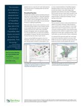
“The innovation here is taking our displayed results on a map with color-coded folder properties. The innovative solution for handling problem files delivered impressive results. Streamlined Searches geospatial level. Geospatial data simplified searches and produced more accurate results for various departments. Integrating ProjectWise with the Esri geospatial database, for example, allowed the City’s GIS staff to search for geospatially correct CAD files from a toolbar directly within ArcMap. This also streamlined the process of updating the geodatabase. It’s the new level of ProjectWise. We...
Open the catalog to page 2All Bentley Systems Europe B.V. catalogs and technical brochures
 Digital Airport Project Showcase
18 Pages
 Water_Hazelwood_Coal_Mine
2 Pages
 Water_Simtejo_case_study
2 Pages
 Wimbledon Stadium_Case Study
2 Pages
 WSP-Shard_Case_Study
3 Pages
 Bentley’s Water Project Showcase
92 Pages
 Mine Water Software Solution
4 Pages
 AutoPLANT Equipment V8i
2 Pages
 AutoPLANT Piping V8i
2 Pages
 ConstructSim
2 Pages
 promis•e
2 Pages
 Bentley Datasheets
2 Pages
 Making PDS Interoperable
17 Pages
 Bentley OpenPlant PowerPID
2 Pages
 STAAD.Pro
2 Pages


Archived catalogs
 Water modelling
24 Pages
 Bentley Water V8 XM
2 Pages
 Bentley Cadastre Specsheet
2 Pages
 STAAD Foundation
2 Pages
 RAM CADStudio
2 Pages
 Bentley MAP
2 Pages
 Bentley Structural Brochure
2 Pages
 Bentley Project Yearbook 2006
82 Pages
 Bentley SewerCAD
2 Pages
 Bentley WaterCAD
2 Pages
 Bentley WaterGEMS
2 Pages
 Bentley HAMMER
2 Pages
 Bentley StormCAD
2 Pages
 Bentley SewerGEMS
2 Pages
 Bentley AutoPlant P&ID
2 Pages
 Bentley Microstation
2 Pages
 Bentley Architecture
2 Pages
 Bentley ProjectWise brochure
2 Pages
 Bentley CivilStorm
2 Pages
 Bentley ProjectWise
4 Pages
 Bentley PowerDraft
2 Pages
 Bentley AutoPipe Specsheet
2 Pages


- Automation software solution
- Management software solution
- Analysis software solution
- Process software
- Windows software
- Real-time software
- Computer-aided design software
- Cloud-based software
- Control software
- Design software solution
- 3D software solution
- Industrial software
- Interface software
- Visualization software solution
- Quality software
- Simulation software solution
- Automated software
- Programming software
- Development software
- Network software