- Catalogs
- Bentley Systems Europe B.V.
- 3D Reality Mesh of Penn State’s University Park Campus Generated with ContextCapture
- Products
- Catalogs
- News & Trends
- Exhibitions
3D Reality Mesh of Penn State’s University Park Campus Generated with ContextCapture
1 /2Pages

3D Reality Mesh of Penn State’s University Park Campus Generated with ContextCapture
1 /2Pages
Catalog excerpts
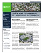
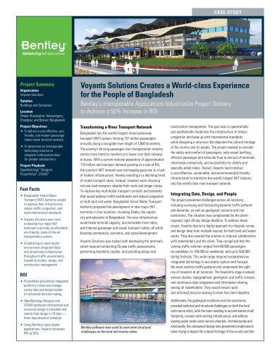
CASE STUDY Project Summary Organization: Pennsylvania State University Solution: Reality Modeling Location: State College, Pennsylvania, United States Project Objective: • Integrate disparate and disconnected datasets from custom enterprise data systems into a 3D reality mesh. • Leverage reality modeling to support real-time infrastructure planning and ongoing maintenance and management. Products Used: ContextCapture, iModel Transformer, MicroStation, and ProjectWise Fast Facts • Penn State used ContextCapture to deliver a 3D virtual model of its University Park campus from 2,500 aerial images. • Disparate datasets from custom data systems were integrated to produce a geospatially accurate composite iModel that was combined with the 3D reality mesh. • ProjectWise served as the common interface for the model, providing high-performance streaming and sharing real-time information among stakeholders. ROI • Aerial images were processed and a 3D reality mesh was created in less than 48 hours with ContextCapture. • The virtual campus model enables facility managers to visualize accurate locations of work orders, increase response time, and improve performance for more efficient asset maintenance and management. 3D Reality Mesh of Penn State’s University Park Campus Generated with ContextCapture Bentley’s Reality-capture Technology Provides an Integrated Data Solution A Virtual Campus Initiative Founded in 1855 with more than 24 campuses serving nearly 100,000 students, Pennsylvania State University (Penn State) is the state’s largest public university and has been ranked a leader in higher education for more than 150 years. The entire education system encompasses more than 23,000 acres and maintains close to 2,000 buildings and structures statewide. To control costs and more efficiently manage and operate the huge number of facilities, the university realized that using BIM and GIS datasets to create a digital model would not be enough. The college set out to integrate the enormous amounts of asset, financial, space management, maintenance, project, and BIM data into a 3D reality mesh, creating a virtual campus model. ContextCapture Provides a Cost-effective Photogrammetric Solution Given the sheer size and number of structures and assets on the University Park campus, using traditional reality-capture technology such as 3D laser scanning was not a viable option. It is time consuming to capture the buildings and surrounding area and requires a large amount of work to stitch together separate models as a whole model. Using Bentley’s ContextCapture photogrammetry software simplified the process and enabled the team to quickly and cost effectively generate a highly detailed, geospatially accurate 3D reality mesh from digital aerial images. A manned Cessna aircraft was flown approximately 1,000 feet above ground, and with a handheld highThis virtual 3D campus would act as a single interface into resolution camera, the flight team captured almost 2,500 the numerous data sources the school relies on for daily and photos within two hours of flight time. The team used long-term operations and ensure that facility maintenance ContextCapture to process personnel could access the the images, and, relying on the asset data to perform their automated capabilities of the jobs effectively. The project software to create contextual team decided to implement content, the team produced the virtual campus initiative a 3D texturized reality mesh at the school’s main campus, in less than two days. The University Park in State generated campus model College, which comprises is a large, 3D scalable 945 buildings and structures mesh that includes detailed spanning 79 acres and occupied representation of each campus by 46,000 undergraduate stubuilding, including enclosures, dents. To timely and efficiently auxiliary structures, facades, capture images and develop hardscape, and landscaping a precise reality mesh of the Precisely detailed and geospatially accurate 3D reality meshes elements, enabling more numerous buildings, assets, of campus facilities were generated from digital aerial images informed decisions regarding through ContextCapture photogrammetry software. and surrounding area, the structural maintenance and team needed advanced reality reducing time necessary to survey existing conditions for modeling technology. Compounded by an additional serious retrofit projects. With 3D viewing capability in relation to the data integration issue, the project required a collaborative, surrounding area, the reality mesh provides an understanding interoperable framework to integrate the disparate and of spatial constraints prior to maintenance work, minimizing disconnected datasets from the university’s custom enterprise risk and improving safety. data syste
Open the catalog to page 1
"The Virtual Penn State initiative using ContextCapture, iModel [Transformer], and ProjectWise to create an accurate and complete model of the campus and overlay CMMS data has provided both initial and potential benefits for maintenance activities for the Office of Physical Plant." - Craig Dubler, Facility Asset Management Program Manager, Penn State Find out about Bentley at: www.bentley.com Contact Bentley 1-800-BENTLEY (1-800-236-8539) Outside the US +1 610-458-5000 Global Office Listings www.bentley.com/contact Interoperability Facilitates Data Integration The reality mesh generated by ContextCapture...
Open the catalog to page 2All Bentley Systems Europe B.V. catalogs and technical brochures
 Digital Airport Project Showcase
18 Pages
 Water_Hazelwood_Coal_Mine
2 Pages
 Water_Simtejo_case_study
2 Pages
 Wimbledon Stadium_Case Study
2 Pages
 WSP-Shard_Case_Study
3 Pages
 Bentley’s Water Project Showcase
92 Pages
 Mine Water Software Solution
4 Pages
 AutoPLANT Equipment V8i
2 Pages
 AutoPLANT Piping V8i
2 Pages
 ConstructSim
2 Pages
 promis•e
2 Pages
 Bentley Datasheets
2 Pages
 Making PDS Interoperable
17 Pages
 Bentley OpenPlant PowerPID
2 Pages
 STAAD.Pro
2 Pages


Archived catalogs
 Water modelling
24 Pages
 Bentley Water V8 XM
2 Pages
 Bentley Cadastre Specsheet
2 Pages
 STAAD Foundation
2 Pages
 RAM CADStudio
2 Pages
 Bentley MAP
2 Pages
 Bentley Structural Brochure
2 Pages
 Bentley Project Yearbook 2006
82 Pages
 Bentley SewerCAD
2 Pages
 Bentley WaterCAD
2 Pages
 Bentley WaterGEMS
2 Pages
 Bentley HAMMER
2 Pages
 Bentley StormCAD
2 Pages
 Bentley SewerGEMS
2 Pages
 Bentley AutoPlant P&ID
2 Pages
 Bentley Microstation
2 Pages
 Bentley Architecture
2 Pages
 Bentley ProjectWise brochure
2 Pages
 Bentley CivilStorm
2 Pages
 Bentley ProjectWise
4 Pages
 Bentley PowerDraft
2 Pages
 Bentley AutoPipe Specsheet
2 Pages


- Automation software solution
- Management software solution
- Analysis software solution
- Process software
- Windows software
- Real-time software
- Computer-aided design software
- Cloud-based software
- Control software
- Design software solution
- 3D software solution
- Industrial software
- Interface software
- Visualization software solution
- Quality software
- Simulation software solution
- Automated software
- Programming software
- Development software
- Network software