AutoCAD Raster Design

AutoCAD Raster Design
AutoCAD Raster Design software is a powerful tool designed to enhance, preserve, and maintain raster assets such as scanned drawings, maps, aerial photos, and satellite imagery. It integrates seamlessly with various AutoCAD products, providing a familiar environment for users to work with raster data.
Key Features
- Image Cleanup and Enhancement: The software offers tools like despeckle, deskew, and bias correction to improve the quality and usability of scanned images. It also includes image-processing features such as histogram equalization, brightness and contrast adjustment, and convolve filters for smoothing and sharpening images.
- Raster-to-Vector Conversion: AutoCAD Raster Design allows users to convert raster lines, arcs, and text into vector formats, facilitating the integration of scanned data into AutoCAD-based projects.
- Optical Character Recognition (OCR): This feature enables the recognition and conversion of machine and hand-printed text on raster images into AutoCAD text, improving accuracy and reducing manual data entry time.
- Geospatial Imagery Utilization: When used with AutoCAD Map 3D, the software provides additional functionality for utilizing geospatial imagery, allowing users to create color elevation representations and visualize environmental information.
Applications and Benefits
AutoCAD Raster Design is beneficial for professionals across various industries, including civil engineering, GIS/mapping, mechanical, electrical, plumbing (MEP), architectural, and manufacturing. It helps in:
- Reducing the need for multiple applications by working within the AutoCAD environment.
- Unlocking and extending the value of existing design information.
- Improving decision-making by integrating rich imagery into proposals and presentations.
Conclusion
AutoCAD Raster Design is a comprehensive solution for managing and enhancing raster data, offering tools that streamline workflows and improve the quality of design projects. It supports a wide range of image formats, making it a versatile choice for design professionals.
Catalog excerpts
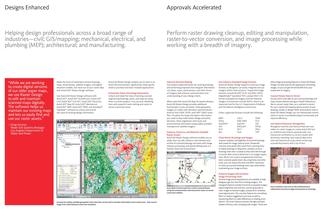
Make the most of rasterized scanned drawings, maps, aerial photos, satellite imagery, and digital elevation models. Get more out of your raster data with AutoCAD AutoCAD Raster Design enables you to work in an AutoCAD environment, significantly reducing the need to purchase and learn multiple applications. Improve Decision Making Use Industry-Standard Image Formats other image-processing features in AutoCAD Raster Design can help improve the appearance of existing images, so you can get the full benefit from your investment in imagery. Get projects approved faster by creating drawings and presenting...
Open the catalog to page 2All AUTODESK catalogs and technical brochures
 Autodesk ® Flame®
2576 Pages
 Autodesk® In Games
7 Pages
 Autodesk® DirectConnect
80 Pages
 AUTODESK ® 3DS MAX
1358 Pages
 CEIT-KE
2 Pages
 Novax DMA
2 Pages
 autocad_civil3d
6 Pages
 building_design_suite_2013
4 Pages
 autocad_design_suite_2013
2 Pages
 autocad_mep_brochure
4 Pages
 acade_jic_overview_broch_us
4 Pages
 alias_2013_
10 Pages
 Autodesk Utility Design
2 Pages
 Autodesk Toxik
4 Pages
 Autodesk Subcontractor
4 Pages
 Autodesk Smoke
2 Pages
 Autodesk Mudbox
4 Pages
 Autodesk MotionBuilder
4 Pages
 Autodesk Moldflow Adviser
4 Pages
 Autodesk Maya
4 Pages
 Autodesk Lustre
6 Pages
 Autodesk LandXplorer
4 Pages
 Autodesk Inferno
1 Page
 Autodesk Flare
1 Page
 Autodesk Flint
1 Page
 Autodesk Cleaner XL
2 Pages
 Autodesk Cleaner
2 Pages
 Autodesk Buzzsaw
4 Pages
 Autodesk Backdraft Conform
6 Pages
 AutoCAD Revit MEP Suite
4 Pages
 AutoCAD P&ID
4 Pages
 AutoCAD Inventor Suites
32 Pages
 AutoCAD Electrical
4 Pages
 Autodesk Quantity Takeoff
4 Pages
 Autodesk Revit Structure
8 Pages
 AutoCAD Civil
6 Pages


Archived catalogs
 AutoCAD MEP
6 Pages
 Autodesk Navisworks Review
4 Pages
 AutoCAD Civil 3D
2 Pages
 factory_design_suite_2013
4 Pages
 Autodesk 3ds Max Design
4 Pages
 AutoCAD Map 3D
4 Pages
 AutoCAD Mechanical
4 Pages
 AutoCAD Structural Detailing
6 Pages
 Autodesk Alias Design
4 Pages
 Autodesk Alias Surface
4 Pages
 Autodesk Revit Structure
8 Pages
 AutoCAD LT
2 Pages
 Autodesk MapGuide Enterprise
4 Pages
 Autodesk Topobase
2 Pages
 Autodesk Ecotect Analysis
4 Pages
 AutoCAD Architecture
4 Pages
 acade_jic
4 Pages
 autocad_lt_2013
2 Pages
 3DS
3DS8 Pages
 map3D_2013
2 Pages
 BIM and Visualization
11 Pages


- SARRALLE management software
- SARRALLE automation software
- SARRALLE analysis software
- SARRALLE process software
- SARRALLE Windows software
- SARRALLE real-time software
- SARRALLE CAD software
- SARRALLE cloud software
- SARRALLE control software
- SARRALLE 3D software
- SARRALLE industrial software
- SARRALLE interface software
- Measurement software
- SARRALLE quality software
- SARRALLE visualization software
- SARRALLE simulation software
- SARRALLE automated software
- SARRALLE programming software
- SARRALLE development software