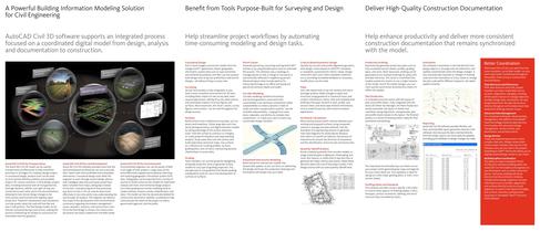
AutoCAD Civil 3D

AutoCAD Civil 3D
Utilize Autodesk 3ds Max for photorealistic renderings and publish models to Google Earth to explore design alternatives and understand their community and environmental impact.
Focus on enhancing design quality by evaluating multiple scenarios early in the process, improving service quality, and accessing global specialists through Autodesk resellers.
Autodesk provides various learning solutions, including instructor-led classes, online training, and certifications, along with support services like consulting and productivity tools.
Autodesk Subscription offers software upgrades, exclusive license terms, and community resources for skill enhancement.
Design and analyze stormwater systems with integrated tools to reduce runoff and meet LEED requirements, including Hydraflow extensions for storm sewer design and hydraulic calculations.
Support engineering workflows with geospatial analysis and mapping capabilities to create detailed maps for site selection and design constraint understanding.
AutoCAD Civil 3D supports sustainable design by evaluating alternatives and providing tools for LEED initiatives, including stormwater management.
Provide sustainable alternatives with conceptual design tools, balancing development scope with environmental constraints and creating construction documents from BIM models.
Streamline roadway design processes with analysis tools and synchronized documentation, using visualizations and simulations to predict road performance.
Enhance team coordination with consistent models, data shortcuts, and advanced data management using Autodesk Vault technology.
Extend design review digitally with DWF file format and share transportation design data with structural engineers.
Integrate survey functionality to build surfaces from survey data and analyze water flow for watershed mapping.
Use daylighting and grading tools for surface models and automate parcel generation with topology management.
Create dynamic models of transportation systems with customizable components and interactive intersection models.
Generate production plans synchronized with model changes using comprehensive tools for plan and profile sheet layout.
Control drawing display with country-specific CAD styles and use criteria-based design for alignment geometry.
Lay out drainage systems with rules-based tools, conduct interference checks, and process earth volumes for material movement analysis.
Extract material quantities and generate bid-ready documents with automatic annotation updates.
Generate real-time reports directly from the model for easy updates and flexibility.
Leverage BIM throughout project stages to enhance mapping and analysis of large areas by integrating GIS data.
Import topographical data to construct surface terrain models crucial for watershed analysis and environmental assessments.
Use grading and corridor modeling tools to design channels, streams, ponds, embankments, and dams, facilitating detailed construction documents.
Generate realistic visualizations to effectively communicate project intentions to clients, government agencies, and the public.
Catalog excerpts
Conceptual Design Parcel Layout Criteria-Based Geometric Design Production Drafting Annotation Pull in aerial imagery and terrain models from the Google Earth application; import geographic information system data such as road centerlines and wetlands boundaries; and then use the purpose-built design tools to lay out preliminary road and lot designsٗall without hiring a survey crew. Generate parcels by converting existing AutoCAD > entities or by using flexible layout tools to automate the process. The software uses a topology to manage parcels so that a change to one parcel is automatically...
Open the catalog to page 2All AUTODESK catalogs and technical brochures
 Autodesk ® Flame®
2576 Pages
 Autodesk® In Games
7 Pages
 Autodesk® DirectConnect
80 Pages
 AUTODESK ® 3DS MAX
1358 Pages
 CEIT-KE
2 Pages
 Novax DMA
2 Pages
 autocad_civil3d
6 Pages
 building_design_suite_2013
4 Pages
 autocad_design_suite_2013
2 Pages
 autocad_mep_brochure
4 Pages
 acade_jic_overview_broch_us
4 Pages
 alias_2013_
10 Pages
 Autodesk Utility Design
2 Pages
 Autodesk Toxik
4 Pages
 Autodesk Subcontractor
4 Pages
 Autodesk Smoke
2 Pages
 Autodesk Mudbox
4 Pages
 Autodesk MotionBuilder
4 Pages
 Autodesk Moldflow Adviser
4 Pages
 Autodesk Maya
4 Pages
 Autodesk Lustre
6 Pages
 Autodesk LandXplorer
4 Pages
 Autodesk Inferno
1 Page
 Autodesk Flare
1 Page
 Autodesk Flint
1 Page
 Autodesk Cleaner XL
2 Pages
 Autodesk Cleaner
2 Pages
 Autodesk Buzzsaw
4 Pages
 Autodesk Backdraft Conform
6 Pages
 AutoCAD Revit MEP Suite
4 Pages
 AutoCAD P&ID
4 Pages
 AutoCAD Inventor Suites
32 Pages
 AutoCAD Electrical
4 Pages
 Autodesk Quantity Takeoff
4 Pages
 Autodesk Revit Structure
8 Pages
 AutoCAD Civil
6 Pages


Archived catalogs
 AutoCAD Raster Design
2 Pages
 AutoCAD MEP
6 Pages
 Autodesk Navisworks Review
4 Pages
 factory_design_suite_2013
4 Pages
 Autodesk 3ds Max Design
4 Pages
 AutoCAD Map 3D
4 Pages
 AutoCAD Mechanical
4 Pages
 AutoCAD Structural Detailing
6 Pages
 Autodesk Alias Design
4 Pages
 Autodesk Alias Surface
4 Pages
 Autodesk Revit Structure
8 Pages
 AutoCAD LT
2 Pages
 Autodesk MapGuide Enterprise
4 Pages
 Autodesk Topobase
2 Pages
 Autodesk Ecotect Analysis
4 Pages
 AutoCAD Architecture
4 Pages
 acade_jic
4 Pages
 autocad_lt_2013
2 Pages
 3DS
3DS8 Pages
 map3D_2013
2 Pages
 BIM and Visualization
11 Pages


- SARRALLE management software
- SARRALLE automation software
- SARRALLE analysis software
- SARRALLE process software
- SARRALLE Windows software
- SARRALLE real-time software
- SARRALLE CAD software
- SARRALLE cloud software
- SARRALLE control software
- SARRALLE design software
- SARRALLE 3D software
- SARRALLE industrial software
- SARRALLE interface software
- Measurement software
- SARRALLE quality software
- SARRALLE visualization software
- SARRALLE simulation software
- SARRALLE automated software
- SARRALLE programming software
- SARRALLE development software