- Catalogs
- Aeryon Labs Inc.
- Photo3S High Resolution Camera
Photo3S High Resolution Camera
1 /2Pages

Photo3S High Resolution Camera
1 /2Pages
Catalog excerpts
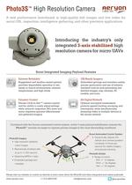
Photo3S™ High Resolution Camera A new performance benchmark in high-quality still images and live video for aerial GIS, inspection, intelligence gathering, and other precision applications Introducing the industry’s only integrated 3-axis stabilized high resolution camera for micro UAVs Scout Integrated Imaging Payload Features Extreme Reliability GIS-Ready Imagery Ruggedized and weather-sealed gimbal provides dependable operation in wet, sandy, or humid environments, extreme temperatures, and high winds Embedded geotags and metadata enable precise geolocation and use of industry standard tools for post-processing into stitched images, map overlays, 3D models, and more Dynamic Control All-Digital Network Precise Click-to-Aim™ camera control and the ability to easily adjust settings while airborne (exposure, ISO, zoom and more) improves operator effectiveness and gathered imagery Optional encrypted transmission protects against hacking, snooping, and interception, while simultaneously streaming video to multiple devices in the secure network Combined with the Scout's automated control system, active 3-axis payload stabilization ensures the Photo3S™ remains on-target to capture precise images in the most demanding conditions Scout Automated Control System q #XM@LHB@KKX @CITRSR SGD UDGHBKD @MC B@LDQ@ ONRHSHNM GTMCQDCR NE SHLDR ODQ RDBNMC ENQ RS@AKD HL@FDQX @MC OQDBHRD SQ@BJHMF Photo3S Imagery q 'HFG QDRNKTSHNM RS@AHKHYDC BNKNTQ HL@FDR q ,DBG@MHB@KKX RGTSSDQDC RSHKKR @S TO SN RDBNMC Photo3S Gimbal q 1@MFD NE LNSHNM 1NKK CDFQDDR /HSBG CDFQDDR 8@V CDFQDDR q 2SQD@LHMF ,/$& UHCDN q $LADCCDC FDNS@FR @MC LDS@C@S@ Please visit our website or contact us directly to learn more about the Photo3S and other integrated and custom payloads www.aeryon.com +1 519-489-6726 [email protected] @aeryonlabs
Open the catalog to page 1
Example Aerial Imaging Applications for the Aeryon Scout and the New Photo3S™ Camera Aerial Inspection Source: ING Engineering High resolution aerial images enable detailed component inspection of difficult-to-access infrastructure, while minimizing expensive operational downtime and removing the human element from potentially hazardous environments Aerial Mapping and GIS Source: University of Alaska Fairbanks Source: Geo-Rhea The Scout’s AutoGrid™ flight planning software allows fast collection of images that are automatically geotagged for processing by industry standard tools into stitched...
Open the catalog to page 2All Aeryon Labs Inc. catalogs and technical brochures
 Aeryon Map Edition
2 Pages
 SR-EO/IR Mk II
2 Pages
 HDZoom30 Inspection brochure
2 Pages
 HDZoom30 brochure tactical
2 Pages
 Aeryon SkyRanger
2 Pages
 VideoZoom10x Payload
2 Pages
 Aerial Vehicle Systems
2 Pages


- Safety Clamps digital camera
- Safety Clamps visible camera
- Infrared imager
- Monitoring camera system
- Safety Clamps full-color camera
- HD camera module
- Rugged camera
- Zoom imager
- CCTV camera system
- Multi-spectral camera
- Safety Clamps rotary wing UAV
- Camera for airborne applications
- Safety Clamps quadrotor UAV
- UAV camera module
- Stabilized camera
- Civilian UAV
- 3-axis camera