
カタログの抜粋

Galaxy T2000 Airborne Lidar Terrain Mapper Maximum productivity for wide-area, mountain, urban and corridor survey applications Continuous Operating Envelope The new ALTM Galaxy T2000 is the ultimate wide-area lidar sensor, with best-of-class density performance and collection efficiency, delivering the highest quality data sets to meet rigorous USGS lidar standards. Now with a 6500 m AGL collection envelope and 2-MHz “on-ground” collection rate, Galaxy is quite simply the highestperformance sensor on the market in the smallest form factor for maximum application and platform flexibility. Whether gyro-stabilized or fixed-mounted, high-altitude or low, one camera or six, one Galaxy or two, the Galaxy T2000 excels in all application areas with unmatched configuration flexibility, while providing the highest data precision and accuracy available. » Wide-area mapping » Urban mapping APPLICATIONS » Engineering & infrastructure modeling » Natural resource management Increased Vertical Density » Powerline & transportation corridor Seamlessly Integrated Cameras
カタログの1ページ目を開く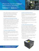
What is the secret to Galaxy’s performance advantage? Galaxy T2000 includes an innovative set of lidar technology enhancements that significantly increases sensor performance and collection efficiency, improves data quality, and greatly simplifies the collection process. 3. Real-time Sensor Protocol THESE NEW ENHANCEMENTS INCLUDE: » Real-time XYZi point display enables true-coverage 1. Continuous Operating Envelope PulseTRAK™ technology enables a truly continuous operating envelope by eliminating the data coverage gaps and irregular point density commonly found with other multipulse-equipped...
カタログの2ページ目を開く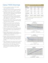
GALAXY T2000 PRODUCTIVITY EXAMPLES » 2-MHz “on-ground” collection rate enables Average Point Density Ground Speed Instantaneous Coverage Rate 4 unprecedented point density. » Large performance envelope ensures collection confidence in both flat and rugged terrain types. » PulseTRAK™ technology enables a continuous operating envelope that can accommodate highrelief terrain with no data gaps or loss of density across multipulse transition zones. » SwathTRAK™ technology can reduce operating costs by as much as 70% by maintaining fixedwidth flightlines for consistent point density and fewer...
カタログの3ページ目を開く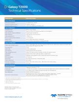
Galaxy T2000 Technical Specifications PARAMETER Sensor Performance Performance envelope 1, 2, 3, 4 Absolute horizontal accuracy 2, 3 Absolute elevation accuracy 2, 3 Laser Configuration Topographic laser Laser classification Pulse repetition frequency (effective) Beam divergence Laser range precision 5 Minimum target separation distance Range capture Up to 8 range measurements, including last Intensity capture Up to 8 intensity measurements, including last (12-bit) Sensor Configuration Position and orientation system POS AV™ AP60 (OEM); 220-channel dual frequency GNSS receiver; GNSS airborne...
カタログの4ページ目を開くOptechのすべてのカタログと技術パンフレット
-
 Galaxy PRIME Plus
4 ページ
-
 Galaxy PRIME
4 ページ
-
 CM2000
2 ページ
-
 CL-360
4 ページ
-
 T2000
T20004 ページ
-
 TLS-M3
2 ページ
-
 Lynx Camera
2 ページ
-
 Corridor Mapping
2 ページ
-
 PEGASUS HA500
2 ページ
-
 Lidar bathymetry
1 ページ
-
 ORION M/C 300
1 ページ
-
 Lynx Mobile Mapper
2 ページ
-
 Optech CZMIL
2 ページ
-
 GEMINI
2 ページ
-
 LYNX Brochure
16 ページ
-
 ORION H/M/C 300
2 ページ
-
 ILRIS - LR
2 ページ
-
 Optech Hydrofusion
2 ページ
-
 AIRBORNE BROCHURE
16 ページ
-
 AQUARIUS
2 ページ


カタログアーカイブ
-
 ALTM NAV Software
1 ページ
-
 Space Lidar Systems
2 ページ
-
 CMS Wireless
2 ページ
-
 ALTM Gemini
2 ページ
-
 ALTM Gemini 167
2 ページ


