
Catalog excerpts

Dual Wavelength Waveform Processing Airborne LiDAR Scanning System for High-Point Density Mapping Applications RIEGL VQ-1560i-DW • enhanced target characterization based upon simultaneous measurements at green and infrared laser wavelengths • high laser pulse repetition rate of up to 1 MHz per laser channel • up to 1.33 million measurements per second on the ground • data acquisition at a wide range of point densities • excellent multiple target capability • enables Multiple-Time-Around (MTA) processing of up to 20 pulses simultaneously in the air • online waveform processing as well as smart and full waveform recording for both LiDAR channels • integrated inertial measurement unit and GNSS receiver • integrated, easily accessible medium format camera • prepared for integration of a secondary camera • high-speed fiber data interface to RIEGL data recorder • housing shape and mounting flange optimized for interfacing with typical hatches and stabilized platforms The VQ-1560i-DW is an airborne LiDAR scanning system offering two LiDAR channels of different wavelengths, green and infrared (IR). These wavelengths are well chosen to allow the acquisition of scan data of complementary information content, thus delivering two independent reflectance distribution maps, one per laser wavelength. Scan data acquired with the RIEGL VQ-1560i-DW are the input for wellestablished scan data processing methods but also for the development of highly sophisticated data processing and evaluation algorithms for new areas of application like vegetation mapping in agriculture and forestry. Thus the VQ-1560i-DW offers innovative technology for commercial as well as scientific and research applications. The VQ-1560i-DW provides a laser pulse repetition rate of up to 1MHz per LiDAR channel, resulting in a total of more than 1.3 million measurements per second on the ground. The VQ-1560i-DW works at highest productivity when both LiDAR channels are combined, typically at altitudes up to 8300 ft. However, each channel is also prepared for stand-alone operation. This channel selection capability in combination with a matched line of measurement programs as well as widely variable scan parameters enable highest possible flexibility for meeting highly specific requirements of challenging application scenarios. The system is completed by a high performance IMU/GNSS unit and up to two optional cameras. A 150 megapixels RGB camera is intended to be used as primary camera, as secondary camera a thermal or a NIR camera can be built in. The mounting flange is optimized for simple interfacing with typical aircraft hatches and stabilized mounts by means of a specific adapter ring. Applications: • cientific and Research Applications S • Agriculture and Forestry • Mapping of Vegetation and Normalized Difference Vegetation Index (NDVI) • Glacier & Snowfield Mapping • Mapping of Lake Sides & River Banks • High Point Density Mapping • Corridor Mapping visit our website www.riegl.com
Open the catalog to page 1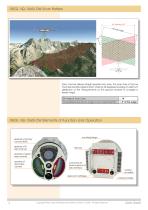
RIEGL VQ-1560i-DW Scan Pattern Each channel delivers straight parallel scan lines. The scan lines of the two channels are tilted against each other by 28 degrees providing an optimum distribution of the measurements on the ground invariant to changes in terrain height. Tilt Angle of Scan Lines Forward/Backward Scan Angle in Non-Nadir Direction RIEGL VQ-1560i-DW Elements of Function and Operation aperture of primary camera (RGB) aperture of IR laser channel mounting flange aperture of green laser channel aperture of secondary camera connectors for power supply and data interface desiccant...
Open the catalog to page 2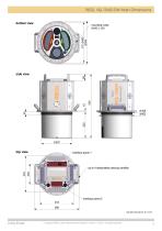
RIEGL VQ-1560i-DW Main Dimensions Data Sheet Copyright RIEGL Laser Measurement Systems GmbH © 2022– All rights reserved.
Open the catalog to page 3
RIEGL VQ-1560i-DW System Components GNSS antenna USB 3.0 interface high speed interface LAN interface - flight guidance LAN interface - system control control for gyro-stabilized mount laser safety switch laser safety switch RIEGL VQ-1560i-DW pilot display flight guidance (optional) gyro-stabilized mount GSM-4000 (optional) operator working station (optional) A minimum number of system components and external cabling is required for an easy and quick installation in aircrafts. RIEGL VQ-1560i-DW Installation Examples RIEGL VQ-1560i-DW installed in the nose pod of fixed-wing aircraft DA42 MPP...
Open the catalog to page 4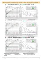
Measurement Range & Point Density - Green and IR Laser Channel PRR = 2x700 kHz, laser power level 100%, green and IR laser channel [m] white marble cliffs, sand, masonry deciduous trees coniferous trees terra cotta concrete wood beam trees, grass, terra cotta quartz sand TYPICAL ENOHD white plaster work, limestone Swath Width 7000 Total Point Density [pts/m2] Operating Flight Altitude AGL Flight Altitude AGL Swath Width 35 Area Acquisition Rate [km²/h] @ visibility 40 km @ visibility 23 km @ visibility 15 km Target Reflectance [%] Example: VQ-1560i-DW at 2 x 700,000 pulses/sec, laser power...
Open the catalog to page 5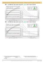
Measurement Range & Point Density - Green and IR Laser Channel PRR = 2x1000 kHz, laser power level 25%, green and IR laser channel [m] @ visibility 40 km @ visibility 23 km @ visibility 15 km cliffs, sand, masonry deciduous trees terra cotta concrete wood beam trees, grass, terra cotta TYPICAL ENOHD quartz sand white plaster work, limestone white marble Swath Width Total Point Density [pts/m2] Operating Flight Altitude AGL coniferous trees Area Acquisition Rate [km²/h] Flight Altitude AGL Swath Width Target Reflectance [%] Example: VQ-1560i-DW at 2 x 1,000,000 pulses/sec, laser power level 25%...
Open the catalog to page 6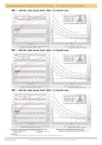
Measurement Range & Point Density - IR Laser Channel Only PRR = 150 kHz, laser power level 100%, IR channel only 16000 Operating Flight Altitude AGL TYPICAL ENOHD cliffs, sand, masonry deciduous trees terra cotta coniferous trees white plaster work, limestone Flight Altitude AGL Swath Width 1.75 Area Acquisition Rate [km²/h] @ visibility 40 km @ visibility 23 km @ visibility 15 km Target Reflectance [%] Example: VQ-1560i-DW at 150,000 pulses/sec, laser power level 100% Altitude = 15,000 ft AGL, Speed = 150 kn Results: Point Density ~ 0.25 pts/m² Area Acquisition Rate ~ 1130 km²/h PRR = 250 kHz,...
Open the catalog to page 7All RIEGL LMS catalogs and technical brochures
-
 RIEGL VQ-840-GE
6 Pages
-
 RIEGL VQ-840-GL
6 Pages
-
 RIEGL RiLOC-E
1 Pages
-
 RIEGL VQ-1560 II-S
10 Pages
-
 RIEGL VQ-780 II-S
8 Pages
-
 RIEGL VQ-780 II
8 Pages
-
 RIEGL VUX-240-24
6 Pages
-
 RIEGL VQ-1460
10 Pages
-
 RIEGL LD05e-A30-PH67
5 Pages
-
 RIEGL LD05-A10GF
10 Pages
-
 LD05e-A10, LD05e-A30
4 Pages
-
 RIEGL VQ-680 OEM
6 Pages
-
 RIEGL VUX-240
6 Pages
-
 RIEGL VUX-180-24
6 Pages
-
 VUX-160²³
6 Pages
-
 RIEGL VQ-580 II-S
8 Pages
-
 RIEGL VQ-580 II
6 Pages
-
 RIEGL VQ-860-G
6 Pages
-
 RiPROCESS
4 Pages
-
 RIEGL VQ-680
6 Pages
-
 RIEGL VQ-1260
10 Pages
-
 RIEGL VQX-2 Helicopter Pod
4 Pages
-
 RIEGL VZ-600i
8 Pages
-
 RIEGL ULS Overview
1 Pages
-
 RIEGL ALS Overview
1 Pages
-
 RIEGL VMY-2
8 Pages
-
 RIEGL VMY-1
4 Pages
-
 RIEGL VMX-RAIL
6 Pages
-
 RIEGL VMX-2HA-BC
2 Pages
-
 RIEGL VMX-2HA
8 Pages
-
 RIEGL VMR
4 Pages
-
 RIEGL VMQ -1HA
6 Pages
-
 RIEGL Mobile Mapping Systems
1 Pages
-
 LIS TreeAnalyzer Plugin
2 Pages
-
 RIEGL VUX-120²³
8 Pages
-
 RIEGL Monitoring Apps
2 Pages
-
 RIEGL VQ-840-G
6 Pages
-
 RIEGL PH-VUX
2 Pages
-
 RIEGL Topo-Bathymetry
4 Pages
-
 RIEGL miniVUX-SYS
4 Pages
-
 RIEGL VUX-1UAV-22
6 Pages
-
 RIEGL VUX-1HA-22
4 Pages
-
 RIEGL VUX-1LR-22
6 Pages
-
 RIEGL V-Line CB23
2 Pages
-
 RIEGL V-Line UB23
2 Pages
-
 RIEGL VQX-1 Wing Pod
4 Pages
-
 RIEGL UAV Sensors & Systems
2 Pages
-
 LIS GeoTec Plugin
2 Pages
-
 RiSCAN PRO
4 Pages
-
 RIEGL VUX-SYS
4 Pages
-
 RIEGL VZ-400i
2 Pages
-
 RIEGL VZ-2000i
10 Pages
-
 RIEGL VZ-400i
10 Pages
-
 RIEGL miniVUX-3UAV
6 Pages
-
 RIEGL miniVUX-1UAV
4 Pages
-
 RiVLib
4 Pages
-
 RIEGL VQ-480 II
6 Pages
-
 RiACQUIRE
4 Pages
-
 RiUNITE
4 Pages
-
 RIEGL VQ-880-GH
6 Pages
-
 RIEGL VQ-880-G II
6 Pages
-
 RiMINING
4 Pages
-
 RIEGL VMZ
4 Pages
-
 RIEGL VPX-1
2 Pages
-
 RIEGL VP-1
2 Pages
-
 RiSOLVE
4 Pages
-
 RDBLib
2 Pages
-
 RIEGL VZ-6000
6 Pages
-
 RIEGL VZ-4000
6 Pages
-
 RiPANO
4 Pages
-
 RIEGL DR1560i
2 Pages
-
 RiHYDRO
2 Pages
-
 RIEGL LD05e-HT
4 Pages
-
 RIEGL LD05-HTGF
13 Pages
-
 RIEGL VZ-2000i
2 Pages


Archived catalogs
-
 RIEGL miniVUX-1LR
4 Pages
-
 RIEGL miniVUX-2UAV
4 Pages
-
 RIEGL LD05-A80
5 Pages