SHOALS-3000 Product Brochure
1 /2Pages

SHOALS-3000 Product Brochure
1 /2Pages
Catalog excerpts
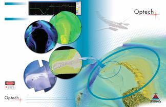
Post-Flight Operations SHOALS airborne data is downloaded fromthe removable hard drives and processed in the SHOALS GCS. The GCS includes a fully-integrated third-party software suite, IVS Fledermaus, to edit and clean 3D data.Applications for SHOALS data include:Nautical chart production ՕShoreline mappingNavigation projectsՕEmergency response Cost-effective support for oil and gas exploration and environmental monitoringՕBeach andcoralreefmanagement.SHOALS also derives sea floor reflectance information (at right) from the lidar return signal. This information is a qualitative estimated measurement ofthe amount of energy returned from the sea floor. The brighter and thus more reflectivethe sea floor is, the moreenergyis returned. For example, an area of bright white sand isrepresented high on the color scale in comparison to a darker sea bottom of weeds or rock. Optech has been the world leader in airborne laser bathymetry for more than 20 years, with approximately 90% market share of systems sold around the globe. Trust Optech to deliver the most advanced bathymetry systems in the world, offering rapid coverage, flexibility, and mobility. Data Cross-Section Profile Applications and Outputs HYDROGRAPHIC CHARTING and MORE... e w n V i 2 D P l a l i m i t s > m > e e t f u t u r e g s c i i e n t i f t u r r e e S i n g c e a n g n s F e n i n n l o e o r g R e f g l e c t a n c e I m a e e l l e n g i n e e d a l l e e n g e d d s C h h a a l l s s C C C h . . . H y d r o d L a s e u r P o i n t C l o SHOALS generates many types of information outputs from just one survey! Shown is a survey of Swan Bay, Australia. From top: Data cross-section profile, 2D plan view, bottom reflectance image, hydro laser point cloud and mosaic of down-look camera images. All information was captured simultaneously in one data collection. Imagery courtesy of AAMHatch. Eyesafe for operators and surface observers with system at standard operational altitude. i c a s o M a e r m C a o k n - L o D o w SHOALS, 3D surface digital elevation model highlighting survey detail area of Swan Bay, Australia. 300 Interchange Way Vaughan, ON Օ Canada L4K 5Z8Web: www.optech.ca/shoals4 Email: [email protected] թ Copyright 2006, Optech Incorporated. All rights reserved. 121806 size="-5">
Open the catalog to page 1All Optech catalogs and technical brochures
 Galaxy PRIME Plus
4 Pages
 Galaxy PRIME
4 Pages
 Galaxy T2000
4 Pages
 CM2000
2 Pages
 CL-360
4 Pages
 T2000
T20004 Pages
 TLS-M3
2 Pages
 Lynx Camera
2 Pages
 Corridor Mapping
2 Pages
 PEGASUS HA500
2 Pages
 Lidar bathymetry
1 Page
 ORION M/C 300
1 Page
 Lynx Mobile Mapper
2 Pages
 ALTM Product Comparison
2 Pages
 Optech CZMIL
2 Pages
 GEMINI
2 Pages
 LYNX Brochure
16 Pages
 ORION H/M/C 300
2 Pages
 ILRIS Terrestrial Solutions
16 Pages
 ILRIS - LR
2 Pages
 Optech Hydrofusion
2 Pages
 Cavity Monitoring System
2 Pages
 AIRBORNE BROCHURE
16 Pages
 AQUARIUS
2 Pages


Archived catalogs
 Space Lidar Systems
2 Pages
 Rollei AIC Digital Camera
2 Pages
 DSS 322 Digital Camera
2 Pages
 ALTM Gemini
2 Pages
 CMS Wireless
2 Pages
 ILRIS Product Catalog
4 Pages
 SHOALS-1000 Product Brochure
4 Pages
 ALTM NAV Software
1 Page
 ALTM Gemini 167
2 Pages


- Real-time software
- Cloud-based software
- Quality software
- 3D scanning system
- Measurement scanner
- CAM software
- Portable scanner
- Office software
- Fixed holder
- Post-processing software
- LIDAR sensor
- Integrated scanner
- Surveying software
- Profile scanner
- Gimbal
- Wireless scanner
- Management software suite
- Automation software suite
- Monitoring software suite