
Catalog excerpts
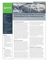
Project Summary Organization The Sanborn Map Company, Inc. Solution Reality Modeling Location Santa Clara County, California, United States Project Objectives • Demonstrate the accuracy of HD maps in the context of a 3D reality model of the Silicon Valley area. • Generate the 3D reality mesh from aerial oblique imagery of the target area. • Overlay the 3D mesh with HD map data that includes a highly detailed inventory of the roadway features required for safe navigation by autonomous vehicles. Products Used ContextCapture Center, Descartes Sanborn Map Highlights HD Map Data Overlaying 3D Reality Mesh for Use in Autonomous Driving ContextCapture Center Creates 3D Environment for Company's Urban HD Map Fast Facts • Sanborn's Advanced Technology group developed proprietary technology for creating standardized, high-precision 3D base maps for self-driving vehicles and markets to be imported in driving simulators, providing a safe, efficient alternative to actual road tests. • ContextCapture Center enabled Sanborn to generate the 3D reality mesh that allows automakers to visualize the context for HD maps at a 7 to 10 centimeter resolution. ROI ContextCapture Center's automated process enabled Sanborn to accomplish 3D reality modeling in a fraction of the time, saving about USD 100,000 compared to traditional methods. Using Bentley's 3D reality modeling software provided an affordable alternative to tying up three of Sanborn's 3D modelers for six months. Precise Maps for Driverless Cars An industry leader in geospatial solutions and technology, The Sanborn Map Company, Inc. is helping to make self-driving cars a reality by creating high-definition (HD) maps used by test-drive simulators for autonomous vehicles. Sanborn partnered with auto manufacturers in a USD 100,000 project that demonstrated the precision of purpose-built HD maps. Using aerial oblique imagery of the target area in Santa Clara County, California Sanborn generated a 3D reality mesh with Bentley's ContextCapture Center software, then overlaid proprietary HD base map data that is accurate within an absolute range of 7 to 10 centimeters. Visualizing the high-precision HD map in the context of a high-resolution 3D urban environment elicited auto company requests for repeat demos internally and with department of transportation regulatory authorities. Bentley applications allowed Sanborn to quickly create 3D reality meshes that would ordinarily take three modelers six months to complete. This made the technology more affordable, allowing Sanborn to provide exceptional value to clients. Safe Test-drive Environment Major auto manufacturers are racing to release self-driving features that give their vehicles some autonomy in specific situations, such as braking to avoid imminent collision. To achieve the goal of a driverless vehicle, manufacturers need to demonstrate that their cars can safely operate in any situation. The RAND corporation estimates that a driverless car would have to drive more than 11 billion miles to prove it is 20 percent safer than a human-driven car. A thousand test cars driving non-stop, 365 days a year would take 50 years to cover that many miles. Simulating the test drive in a virtual world would prove the point in a matter of hours. "Self-driving cars are no longer a futuristic idea," said Sharad V. Oberoi, Ph.D., director of IT and software engineering, with Sanborn Map. "Major auto manufacturers have already released, or are soon to release, self-driving features that give the car some ability to drive itself. Through the 3D mesh generated using ContextCapture Center, Sanborn's Advanced Technology group has been able to showcase the quality of the HD map data, including true-ground-absolute accuracy, to its partner automotive firms. Automating the production of city-sized 3D model with ContextCapture Center made the project much faster than previously possible." Founded in 1866 to produce fire insurance maps, Sanborn evolved with the changing market for imaging and mapping services and today is a first mover in the emerging market for HD maps. Sanborn's Advanced Technology group has developed proprietary HD mapping technology that creates standardized, high-precision 3D base maps for self-driving vehicle models and markets. The HD maps contain more detailed information with true-ground, absolute accuracy than is available in conventional resources such as GPS maps. Compared to current mapping systems that can locate a car's position within 1 meter, HD maps can position a vehicle within less than 10 centimeters. Sanborn provides precise real-world context for HD map data by creating 3D reality models of the environs, drawing upon its expertise in aerial oblique imagery, aerial LiDAR data, and mobile (driven) LiDAR data. For image processing, the map company uses ContextCapture Center, Bentleys reality modeling software for 3D models of any scale. ContextCapture Center generates the 3D engineering-ready reality mesh that Sanborn's HD map data overlays to create the purpose-built, map-based data sets automotive makers need for their virtual worlds. High Definition, Precision, Resolution For the automakers' project, Sanborn acquired aerial oblique imagery of the Silicon Valley area, including Santa Clara, Sunnyvale (Heritage District), Palo Alto, and surrounding locations, to construct a sizeable target area for mapping. The oblique imagery was acquired in a single, multi-pass flight plan using five digital cameras to collect four oblique views and one straight-down (nadir) view. These images were processed using Context Capture Center to quickly produce 3D mesh models of Santa Clara County's complex urban environment. The software automatically aero triangulated the images to identify the position and orientation of each
Open the catalog to page 1
“Sanborn’s Advanced Technology group has been able to showcase the quality of the HD map data, including true-groundabsolute accuracy, to its partner automotive firms. Automating the production of citysized 3D model with ContextCapture Center made the project much faster than previously possible.” – Sharad V. Oberoi, Ph.D., Director of IT & Software Engineering, The Sanborn Map Company, Inc. Find out about Bentley at: www.bentley.com Contact Bentley 1-800-BENTLEY (1-800-236-8539) Outside the US +1 610-458-5000 image, then reconstructed the images as a highly accurate georeferenced 3D...
Open the catalog to page 2All Bentley Systems Europe B.V. catalogs and technical brochures
-
 Digital Airport Project Showcase
18 Pages
-
 Water_Hazelwood_Coal_Mine
2 Pages
-
 Water_Simtejo_case_study
2 Pages
-
 Wimbledon Stadium_Case Study
2 Pages
-
 WSP-Shard_Case_Study
3 Pages
-
 Bentley’s Water Project Showcase
92 Pages
-
 Mine Water Software Solution
4 Pages
-
 AutoPLANT Equipment V8i
2 Pages
-
 AutoPLANT Piping V8i
2 Pages
-
 ConstructSim
2 Pages
-
 promis•e
2 Pages
-
 Bentley Datasheets
2 Pages
-
 Making PDS Interoperable
17 Pages
-
 Bentley OpenPlant PowerPID
2 Pages
-
 STAAD.Pro
2 Pages


Archived catalogs
-
 Water modelling
24 Pages
-
 Bentley Water V8 XM
2 Pages
-
 Bentley Cadastre Specsheet
2 Pages
-
 STAAD Foundation
2 Pages
-
 RAM CADStudio
2 Pages
-
 Bentley MAP
2 Pages
-
 Bentley Structural Brochure
2 Pages
-
 Bentley Project Yearbook 2006
82 Pages
-
 Bentley SewerCAD
2 Pages
-
 Bentley WaterCAD
2 Pages
-
 Bentley WaterGEMS
2 Pages
-
 Bentley HAMMER
2 Pages
-
 Bentley StormCAD
2 Pages
-
 Bentley SewerGEMS
2 Pages
-
 Bentley AutoPlant P&ID
2 Pages
-
 Bentley Microstation
2 Pages
-
 Bentley Architecture
2 Pages
-
 Bentley ProjectWise brochure
2 Pages
-
 Bentley CivilStorm
2 Pages
-
 Bentley ProjectWise
4 Pages
-
 Bentley PowerDraft
2 Pages
-
 Bentley AutoPipe Specsheet
2 Pages


