
Catalog excerpts
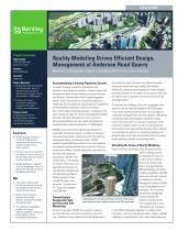
Advancing Infrastructure Project Summary Organization: CEDD-AECOM-Earth Solutions Limited Solution: Reality Modeling Location: Hong Kong Project Objective: • Manage large-scale site formation and infrastructure works for commercial and residential development of a quarry site to accommodate 25,000 people. • Conduct site surveys and monitor construction progress for the client through cross-collaboration. Products Used: ContextCapture, AECOsim Building Designer, Pointools, LumenRT, MicroStation®, OpenRoads, ProjectWise® Reality Modeling Drives Efficient Design, Management of Anderson Road Quarry Bentley's Integrated Solution Enables 4D Construction Process Fast Facts • AECOM managed construction at Anderson Road Quarry to accommodate the urban housing shortage by implementing reality modeling. • The project required management and analysis of massive amounts of data and large-scale site formation on dangerous terrain. • AECOM developed an integrated Site Data Management Solution to optimize planning and construction with Bentley applications. Using reality modeling saved over 255 resource-days per month and enabled the team to achieve a 4D construction process. Bentley's reality modeling solution enhanced work efficiency, streamlined workflows, and reduced rework. This construction management workflow will change traditional workflows in Hong Kong and be applied to future infrastructure development. Accommodating a Soaring Population Growth To support the surge in economic development and population, Hong Kong has invested in numerous large-scale infrastructure works and new building structures. For more than 50 years, Anderson Road Quarry supplied aggregate, asphalt, stone, and concrete for construction programs in Hong Kong. Now a vacated site, Hong Kong's Civil Engineering and Development Department (CEDD) has initiated a USD 1 billion project to develop the quarry in response to the acute housing shortage, the result of rapid population growth. The quarry site offers 40 hectares of land to construct approximately 9,400 private and subsidized housing flats to accommodate a planned population of 25,000 people. AECOM was retained as the engineering consultant for sustainable infrastructure design, including site formation, road improvement works, pedestrian connectivity facilities, underground utilities, and housing estates. AECOM needed integrated BIM advancements and reality modeling technology to optimize planning and construction efficiency, streamline workflows, facilitate stakeholder communication, and meet client reporting requirements. "Based on the complex nature of the project, its variety of infrastructure, and large-scale site formation, we have selected a comprehensive and appropriate package of Bentley solutions to help manage the project more efficiently," explained Ivan H.K. Tsang, vice president at AECOM Asia. ContextCapture Accelerates Safe and Accurate Site Monitoring As part of the project, AECOM was required to report to the client about the construction progress on a monthly basis. Traditional survey methods for the 40-hectare quarry ContextCapture and drone photogrammetryofthe quarry generated accurate reality meshes of the 40-hectare site. site would have been inaccurate and inefficient because the quarry's terrain was steep, sloping, and immense. Additionally, using manual photography to monitor progress would put surveyors at risk, capture only a portion of the area, and take 40 days to complete, missing the required 30-day reporting deadline. To overcome the challenges of the site's topography within the clients 30-day reporting timeframe, AECOM decided to use reality modeling to best monitor the site's progress. Using drone photogrammetry, the team captured 3,000 photos monthly and used ContextCapture to generate a reality mesh of the entire site for an accurate visualization of the construction progress within one day. The 3D precise and real-textured reality mesh provided the team with an efficient and comprehensive platform to oversee site progress and eliminated the need to have on-site staff perform the survey, avoiding potential hazards and improving safety. Extending the Scope of Reality Modeling Beyond creating visualizations, AECOM understood that reality modeling provides a comprehensive record of a site's current conditions that can be utilized in the future. Leveraging Bentley BIM methodology and reality modeling capabilities, AECOM partnered with Earth Solutions to implement a Site Data Management Solution (SDMS), using ContextCapture as the foundation. This innovative construction management solution extended the function of reality meshes from visualizations to more informative uses to achieve a full 4D BIM methodology approach. The ability to add information, such as key construction dates, images, and BIM renderings, to specific points in the reality meshes optimized
Open the catalog to page 1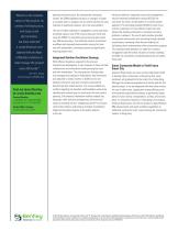
"Based on the complex nature of the project, its variety of infrastructure, and large-scale site formation, we have selected a comprehensive and appropriate package of Bentley solutions to help manage the project more efficiently" - Ivan H.K. Tsang, Vice President, AECOM Asia Find out about Bentley at: www.bentley.com Contact Bentley 1-800-BENTLEY (1-800-236-8539) Outside the US +1 610-458-5000 Global Office Listings www.bentley.com/contact planning and construction. By automatically overlaying models, the SDMS highlights locations or changes in height to visualize works in progress and cut...
Open the catalog to page 2All Bentley Systems Europe B.V. catalogs and technical brochures
-
 Digital Airport Project Showcase
18 Pages
-
 Water_Hazelwood_Coal_Mine
2 Pages
-
 Water_Simtejo_case_study
2 Pages
-
 Wimbledon Stadium_Case Study
2 Pages
-
 WSP-Shard_Case_Study
3 Pages
-
 Bentley’s Water Project Showcase
92 Pages
-
 Mine Water Software Solution
4 Pages
-
 AutoPLANT Equipment V8i
2 Pages
-
 AutoPLANT Piping V8i
2 Pages
-
 ConstructSim
2 Pages
-
 promis•e
2 Pages
-
 Bentley Datasheets
2 Pages
-
 Making PDS Interoperable
17 Pages
-
 Bentley OpenPlant PowerPID
2 Pages
-
 STAAD.Pro
2 Pages


Archived catalogs
-
 Water modelling
24 Pages
-
 Bentley Water V8 XM
2 Pages
-
 Bentley Cadastre Specsheet
2 Pages
-
 STAAD Foundation
2 Pages
-
 RAM CADStudio
2 Pages
-
 Bentley MAP
2 Pages
-
 Bentley Structural Brochure
2 Pages
-
 Bentley Project Yearbook 2006
82 Pages
-
 Bentley SewerCAD
2 Pages
-
 Bentley WaterCAD
2 Pages
-
 Bentley WaterGEMS
2 Pages
-
 Bentley HAMMER
2 Pages
-
 Bentley StormCAD
2 Pages
-
 Bentley SewerGEMS
2 Pages
-
 Bentley AutoPlant P&ID
2 Pages
-
 Bentley Microstation
2 Pages
-
 Bentley Architecture
2 Pages
-
 Bentley ProjectWise brochure
2 Pages
-
 Bentley CivilStorm
2 Pages
-
 Bentley ProjectWise
4 Pages
-
 Bentley PowerDraft
2 Pages
-
 Bentley AutoPipe Specsheet
2 Pages


