
Catalog excerpts
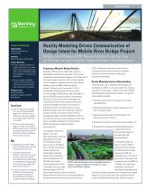
CASE STUDY Project Summary Organization: Alabama Department of Transportation Location: Mobile, Alabama, United States Project Objective: • Provide conceptual designs for bridge infrastructure to increase traffic capacity and allow a more direct route for HAZMAT vehicles along Alabama’s I-10 across the Mobile River. • Minimize impact to Mobile’s maritime industry and the local environment while facilitating easy accessibility for travelers. Products used: Bentley Descartes, OpenRoads, Bentley LumenRT, MicroStation Fast Facts • ALDOT is proposing the design of the country’s second highest bridge with a 215-foot vertical clearance to alleviate congestion and increase capacity along the I-10 corridor. • The new six-lane cable-stayed bridge will replace the George C. Wallace Tunnel, which is expected to generate significant economic benefit for the State of Alabama and the local community. ROI • Using Bentley LumenRT helped reduce animation production time of the project by 70 percent. • LiveCubes generated with Bentley’s visualization and reality modeling software facilitated communication and understanding of the Mobile River Bridge project, crucial to obtaining stakeholder approval and public buy-in. • ALDOT will continue to use Bentley LumenRT to communicate highpriority projects and gain buy-in from stakeholders in the state’s economic development initiatives. Reality Modeling Drives Communication of Design Intent for Mobile River Bridge Project Bentley LumenRT Helps ALDOT Reduce Animation Production Time by 70 Percent on Second Highest Clearance Bridge in the United States Proposing a Massive Bridge Solution Extending 2,500 miles from Jacksonville, Florida, to Santa Monica, California, the Interstate 10 (I-10) is the southernmost transcontinental highway in the United States. It has seen steady increases in traffic volumes resulting in heavy congestion, especially passing through Mobile, Alabama, across the Mobile River through the George C. Wallace Tunnel. Constructed in 1973 to accommodate 36,000 vehicles per day, the tunnel currently averages 73,000 vehicles daily, with peaks as high as 100,000 during tourist season. Compounding the issues of volume, the tunnel was designed with a geometry that results in the reduction of four lanes to two lanes through the tunnel, and a hairpin turn that reduces traffic to 25 miles per hours, causing bottlenecks along the corridor. To alleviate congestion as well as provide a more direct route for vehicles transporting hazardous materials (HAZMAT), which are restricted from using the tunnel resulting in an hour-long detour, the Alabama Department of Transportation (ALDOT) is proposing a bridge and bayway widening project. ALDOT immediately recognized that the only way to communicate the project’s potential and achieve crucial buy-in was to use reality modeling and visualization technology. Reality Modeling Fosters Understanding “There has been a lot of feedback from the public and stakeholders in Mobile, so we were tasked with creating a visualization of the project,” stated J.D. D’Arville, GIS/LRS Data Management Administrator at ALDOT. The goals for reality modeling included: • Illustrating visual impact of the project to the public and stakeholders; • Presenting project details to obtain approval from the FHA for federal funding; • Demonstrating the project’s positive impact on the local economy and city skyline; • Revealing the project’s minimal environmental impact; and • Rendering and simulating the Battleship National Park to show how it will be seen from the bridge and how park traffic will be accommodated. The proposed infrastructure design is a six-lane cable-stayed bridge, spanning approximately 2.75 miles To realistically render the with 215 feet of air draft project in context, ALDOT clearance across the Mobile collected GIS data and more River to protect the maritime than 600 perspective images industry, making it the using aerial LiDAR and second largest clearance helicopters flown for the full 10 bridge in the United States, square miles of the project site after the Golden Gate. The USD 850 million project to capture photos from 600 and ALDOT collected GIS data and more than 600 perspective includes widening 9.25 miles 1,500 feet. The project team images using aerial LiDAR and helicopters to capture of causeway from four to eight photos from 600 and 1,500 feet. used Bentley’s design and lanes and requires ALDOT to visualization technology, along obtain approval and buy-in from the Federal with other third-party applications, to incorporate the mapped Highway Administration (FHA), environmental agencies, imagery into a 3D virtual model of the existing city skyline, local government and businesses, and the community.
Open the catalog to page 1
“Special thank you goes out to Bentley’s visualization team and developer team for providing critical fixes and 3D conceptual model of the entire proposed project with realistic renderings and animations of the driving experience, as well as a 360-degree flyover to provide context from all angles around the city. With Bentley LumenRT, ALDOT created an immersive LiveCube that was especially useful for public communication and understanding, allowing community members to view the model from any virtual perspective— from their home or business residence. “This software makes it easy for the...
Open the catalog to page 2All Bentley Systems Europe B.V. catalogs and technical brochures
-
 Digital Airport Project Showcase
18 Pages
-
 Water_Hazelwood_Coal_Mine
2 Pages
-
 Water_Simtejo_case_study
2 Pages
-
 Wimbledon Stadium_Case Study
2 Pages
-
 WSP-Shard_Case_Study
3 Pages
-
 Bentley’s Water Project Showcase
92 Pages
-
 Mine Water Software Solution
4 Pages
-
 AutoPLANT Equipment V8i
2 Pages
-
 AutoPLANT Piping V8i
2 Pages
-
 ConstructSim
2 Pages
-
 promis•e
2 Pages
-
 Bentley Datasheets
2 Pages
-
 Making PDS Interoperable
17 Pages
-
 Bentley OpenPlant PowerPID
2 Pages
-
 STAAD.Pro
2 Pages


Archived catalogs
-
 Water modelling
24 Pages
-
 Bentley Water V8 XM
2 Pages
-
 Bentley Cadastre Specsheet
2 Pages
-
 STAAD Foundation
2 Pages
-
 RAM CADStudio
2 Pages
-
 Bentley MAP
2 Pages
-
 Bentley Structural Brochure
2 Pages
-
 Bentley Project Yearbook 2006
82 Pages
-
 Bentley SewerCAD
2 Pages
-
 Bentley WaterCAD
2 Pages
-
 Bentley WaterGEMS
2 Pages
-
 Bentley HAMMER
2 Pages
-
 Bentley StormCAD
2 Pages
-
 Bentley SewerGEMS
2 Pages
-
 Bentley AutoPlant P&ID
2 Pages
-
 Bentley Microstation
2 Pages
-
 Bentley Architecture
2 Pages
-
 Bentley ProjectWise brochure
2 Pages
-
 Bentley CivilStorm
2 Pages
-
 Bentley ProjectWise
4 Pages
-
 Bentley PowerDraft
2 Pages
-
 Bentley AutoPipe Specsheet
2 Pages


