
Catalog excerpts
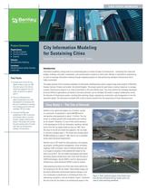
Bentley Sustaiaing Infrastructure Project Summary Organizations: The City of Helsinki Օ The City of Montral Crossrail Solution: City Information Modeling Locations: Helsinki (Finland), Quebec (Canada), London (UK) Introduction Information modeling is being used at an accelerating pace to sustain all types of infrastructure - everything from roads and bridges, buildings, and water, wastewater, and communications systems to entire cities. Bentley is committed to empowering its users to leverage information modeling through integrated projects for high-performing intelligent infrastructure that is highly sustainable. This paper presents three innovative examples of information modeling being used to support large-scale projects in Montreal, Canada, Helsinki, Finland, and London, the United Kingdom. The project teams for each share a common objective: to manage complex infrastructure projects in an urban environment in the most efficient way. The visions behind the strategies developed by these different organizations are based on the same principle: use an intelligent 3D model to support collaboration across the lifecycle of infrastructure assets, including their planning, design, engineering, construction, and management on into the operations phase. The discussion concludes with a look at lessons learned from the experiences of these advanced users. Fast Facts 镕 Helsinki built its first 3D city digital model as early as 1987. Once the value of the 3D city model was apparent, the city made it a priority to expand upon it. The city of Montreal has taken a leadership role in the development of processes and the use of software for creating and managing an accurate and intelligent 3D city model. Օ Crossrail Ltd (CRL) was established in 2001 to promote and develop what is currently Europe's largest infrastructure project. The project will connect the east and the west of London with new rail infrastructure totaling 118 kilometers. ase Study 1 - The City of Helsin Helsinki is the capital and largest city in Finland. Located on a peninsula, its population is about 600,000 and its metropolitan area population is about 1.3 million. The city strives to combine growth with sustainability and livability for its citizens. Therefore, it is one of the world's pioneers in the development of 3D city information modeling. Helsinki built its first 3D city digital model as early as 1987. Once the value of the 3D city model was apparent, the city made it a priority to expand upon it. The model now includes about 45,000 buildings at a scale of 1:500, and its use is extended across many functional departments. Helsinki uses its 3D model for urban planning, civil engineering projects, building permit management, noise simulation, mapping, traffic simulation, and civil defense planning, and is on target to complete a fully-detailed 3D model for the entire city by 2013. The city model encompasses both above and below ground infrastructure and is built with the help of LIDAR technologies. Aerial LIDAR is used for above-ground infrastructure, while terrestrial LIDAR is used for tunnels. Urban planning has been one of the main drivers behind the full rendering of the 3D city model. These lifelike images can be used to effectively communicate planned changes in the city's landscape to practitioners in architectural firms, civil engineering contractors, and city residents. Figure 1 illustrates the use of the 3D city model in an architectural project in the Figure 1: Fully rendered images of the harbor area from the City of Helsinki 3D city model, which are used in urban planning workflows.
Open the catalog to page 1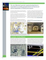
INFORMATION MODELING FOR SUSTAINING CITIES The city of Montreals geomatic engineering department is responsible for providing geospatial data for all internai and external stakeholders in infrastructure projects. city's harbor area. However, Helsinki's use of its 3D city model for urban planning goes far beyond simple visualization to support many other facets of urban planning. For example, it is used to support accurate 3D spatial analysis, and was used to build Helsinki's sea-level protection map. It is also playing a crucial role in helping the city reserve certain areas for planned...
Open the catalog to page 2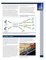
CITY INFORMATION MODELING FQR SUSTAINING CI (vertical walls with some dtails of roof types) and accuracy to within tens of centimeters. For specific areas, 3D models are generated with terrestrial surveying techniques (traditional land surveying as well as laser scanning). Underground infrastructure information from 2D design plans may be extracted from the GIS and included in the model. For years, the city has accomplished this using Bentley's MicroStation®, with the geomatic department using DGN-based modeling to support most internal needs. Now, the city wants to model features as...
Open the catalog to page 3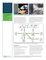
Implementing a 3D city model to address infrastructure needs has put these cities ahead of many other world-class cities. Find out about Bentley at: www.bentley.com Contact Bentley 1-800-BENTLEY (1-800-236-8539) Outside the US +1 610-458-5000 Global Office Listings www.bentley.com/contact Figure 6: The Tottenham Court Road station redesign projectinserted into the 3D model. Design processes at Crossrail required a great deal of collaboration among experts, both inside and outside the organization. To overcome this challenge, Crossrail implemented a server-based system architecture to...
Open the catalog to page 4All Bentley Systems Europe B.V. catalogs and technical brochures
-
 Digital Airport Project Showcase
18 Pages
-
 Water_Hazelwood_Coal_Mine
2 Pages
-
 Water_Simtejo_case_study
2 Pages
-
 Wimbledon Stadium_Case Study
2 Pages
-
 WSP-Shard_Case_Study
3 Pages
-
 Bentley’s Water Project Showcase
92 Pages
-
 Mine Water Software Solution
4 Pages
-
 AutoPLANT Equipment V8i
2 Pages
-
 AutoPLANT Piping V8i
2 Pages
-
 ConstructSim
2 Pages
-
 promis•e
2 Pages
-
 Bentley Datasheets
2 Pages
-
 Making PDS Interoperable
17 Pages
-
 Bentley OpenPlant PowerPID
2 Pages
-
 STAAD.Pro
2 Pages


Archived catalogs
-
 Water modelling
24 Pages
-
 Bentley Water V8 XM
2 Pages
-
 Bentley Cadastre Specsheet
2 Pages
-
 STAAD Foundation
2 Pages
-
 RAM CADStudio
2 Pages
-
 Bentley MAP
2 Pages
-
 Bentley Structural Brochure
2 Pages
-
 Bentley Project Yearbook 2006
82 Pages
-
 Bentley SewerCAD
2 Pages
-
 Bentley WaterCAD
2 Pages
-
 Bentley WaterGEMS
2 Pages
-
 Bentley HAMMER
2 Pages
-
 Bentley StormCAD
2 Pages
-
 Bentley SewerGEMS
2 Pages
-
 Bentley AutoPlant P&ID
2 Pages
-
 Bentley Microstation
2 Pages
-
 Bentley Architecture
2 Pages
-
 Bentley ProjectWise brochure
2 Pages
-
 Bentley CivilStorm
2 Pages
-
 Bentley ProjectWise
4 Pages
-
 Bentley PowerDraft
2 Pages
-
 Bentley AutoPipe Specsheet
2 Pages


